Robert Scott
Active member
Yes there is but I seem to recollect that it might be only one person, Alexander Morphet, not far from the Ribble Way.Apparently there's a family burial ground at High Birkwith Farm (according to the sale brochure)!


Yes there is but I seem to recollect that it might be only one person, Alexander Morphet, not far from the Ribble Way.Apparently there's a family burial ground at High Birkwith Farm (according to the sale brochure)!
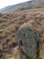
I was flogging round the Turbary Pasture yesterday using Ian's map to try and spot more stones. We walked into it from the south entry via the Turbary Road track then wandered north towards the beck that drops down to Yordas. As we followed this uphill I thought we might spot one of the stones marked by the stream but didn't spot anything. We got to the square enclosure shown on the modern OS map, passed around the south of it and carried on west towards the steep upper slopes. Unexpectedly we came across another boundary stone that I hadn't seen before (pictured). From there we carried on up looking for the original two but missed them (I think we'd gotten too high above them). I got the impression that the stones weren't in the exact locations shown on the old map but without a means of plotting them I couldn't say for sure.
You'll have to go back and record all the GPS coordinates or run circles round them with some running app (Strava or whatever) then you'll see the boundary. Presumably if you follow the contour of the hill from that one (stone has a horizontal line) you'll get to a corner?I was flogging round the Turbary Pasture yesterday using Ian's map to try and spot more stones. We walked into it from the south entry via the Turbary Road track then wandered north towards the beck that drops down to Yordas. As we followed this uphill I thought we might spot one of the stones marked by the stream but didn't spot anything. We got to the square enclosure shown on the modern OS map, passed around the south of it and carried on west towards the steep upper slopes. Unexpectedly we came across another boundary stone that I hadn't seen before (pictured). From there we carried on up looking for the original two but missed them (I think we'd gotten too high above them). I got the impression that the stones weren't in the exact locations shown on the old map but without a means of plotting them I couldn't say for sure.
I don't have Strava, just the OS app. I don't have that particular map downloaded but was using the standard map option to track our route just to see how far we'd go. It's an unreliable app - we had a break as we entered Turbary Pasture then set off looking for the BS nearest the beck - it had stopped recording when I checked again. This seems to happen a lot. I did wonder if the stones would be visible from each other but this doesn't seem to be the case. I was looking for one on the other side of the western boundary wall but didn't go over physically to look and didn't see anything. It requires a team of dedicated seekers fanning out across the pasture. I wonder if the stones pre-date the drystone walls?You'll have to go back and record all the GPS coordinates or run circles round them with some running app (Strava or whatever) then you'll see the boundary. Presumably if you follow the contour of the hill from that one (stone has a horizontal line) you'll get to a corner?
Presumably they would predate walls?I don't have Strava, just the OS app. I don't have that particular map downloaded but was using the standard map option to track our route just to see how far we'd go. It's an unreliable app - we had a break as we entered Turbary Pasture then set off looking for the BS nearest the beck - it had stopped recording when I checked again. This seems to happen a lot. I did wonder if the stones would be visible from each other but this doesn't seem to be the case. I was looking for one on the other side of the western boundary wall but didn't go over physically to look and didn't see anything. It requires a team of dedicated seekers fanning out across the pasture. I wonder if the stones pre-date the drystone walls?
It could be the other way around: OS Bench Marks added to existing Boundary Markers. Bench Marks are typically found on buildings, walls, or other permanent structures and I have seen one locally on some sort of marker stone (possible boundary marker) which although not vertical anymore, had a vertical Bench Mark, so obviously added to the stone at a later date, as I doubt the stone was positioned at such an angle originally.The maps in the record office probably make it clear.
p.s. the highlighted BMs on the map extend into Chapel le Dale, roughly east-west, and have elevations on the map. I think they may be Ordnance Survey Bench Marks rather than the Boundary Markers being discussed here
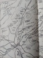
It's shown on this OS 6" map of 1851On the subject of map-based curiosities in the area (so hopefully not too off-topic), does anyone know what "Salad" refers to in the Rowten Pot field (bottom centre of the image below)?
View attachment 21868
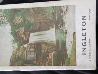
Going by the symbol used around the name I'd imagine it's quite a green and juicy 'Salad'? As for unusual local names, I've just recalled that the hill itself is called 'Grey Garth' on this hand drawn map in the centre of the 1969 Ingleton official guideIt's shown on this OS 6" map of 1851
View attachment 21869
I suppose I should have borne in mind the possibility that BM could also mean 'bench mark'. I used to post prolifically on the Geograph website where people interested in suchlike (and much more!) have recorded thousands of them. I have to say that I didn't see any bench marks on the three carved stones that I have actually clapped eyes on. Given that the OS use them to survey then they have to be visible one from another and that doesn't seem to be the case in Turbary Pasture at least for the stones I was at.
andWhile trig pillars were used as accurate fixed points for mapping coordinates in the National Grid, benchmarks were fixed points which were used to calculate a height above the mean sea level. Benchmarks have been around for a long time, much longer than our trig pillars. While the first systematic network of levelling lines and associated benchmarks was initiated in 1840, some benchmarks in our archive date back to 1831.
Many think it is War Office-related, but it is in fact an OS benchmark (BM) and a means of marking a height above sea level. Surveyors in our history made these marks to record height above Ordnance Datum Newlyn (ODN – mean sea level determined at Newlyn in Cornwall). If the exact height of one BM was known, the exact height of the next could be found by measuring the difference in heights, through a process of spirit levelling. They can be found cut into houses, churches, bridges and many other structures. There are hundreds of thousands of them dotted across Great Britain, although we no longer use them today.
If that is the case what is the actual physical process of using a network of bench marks? Your second quote mentions 'a process of spirit levelling'. I've seen the trig point procedure explained on various documentaries.Bench marks are not the same as Trig Pillars and do not need to be seen from another bench mark.
The benchmark itself need not be visible, but a surveyor's rod / ranging pole standing vertical above the benchmark should be. A "dumpy level" (a combined telescope and spirit level) is used to read the height difference between the two benchmarks. Once upon a time, the telescope had a simple arrangement of lenses and showed an inverted image, so early rods had the numbers written upside down.If that is the case what is the actual physical process of using a network of bench marks? Your second quote mentions 'a process of spirit levelling'. I've seen the trig point procedure explained on various documentaries.
Been years since I've needed to do any spirit leveling. I had no idea that new fangled dumpy would be the right way up?? What will they invent nextThe benchmark itself need not be visible, but a surveyor's rod / ranging pole standing vertical above the benchmark should be. A "dumpy level" (a combined telescope and spirit level) is used to read the height difference between the two benchmarks. Once upon a time, the telescope had a simple arrangement of lenses and showed an inverted image, so early rods had the numbers written upside down.
 (the other thing about upside down was as they slowly rocked the post back and forwards you watched for the "lowest" point on the stripy rod as it went up and down slightly in your view). If circumstances mean I need to hire one from HSS or wherever, I've noted that in brain and will watch out for it possibly being the right way up. Thanks!.
Yes. The foot of the staff is level with the horizontal line. I never had to level from an OS BM so I don't know how they lined them up. On construction sites you'd probably have a vertical steel pin concreted into the ground, and just put the staff on top.Would that be the horizontal line that lies above the arrow cut of the mark?
As shown in the diagram IanWalker posted, you needed an intermediate point while you moved the level, but it's wasn't permanent. Known as a 'change point', anything will do provided it's solid and has a suitable shape to ensure the staff sits at the same level. I suspect the toe cap of the chainman's boot was used sometimes! Although, actually, using the toecap was something you had to watch for when taking the level of the ground before excavation - the more devious contractors would do that so that all the levels were 2" high, and they got paid for removing an extra 2" of soil.Given the massive height increases, (e.g. 1799' to 1995'), they must have had a lot of additional points in between.