

You are using an out of date browser. It may not display this or other websites correctly.
You should upgrade or use an alternative browser.
You should upgrade or use an alternative browser.
Peak Cavern Hydrology - (split from Bradwell catchment topic)
- Thread starter bograt
- Start date
pwhole
Well-known member
Aha! Found it on the TSG forum. If you don't mind, here's your reply to my query from there:
And below is the 'survey' of the shaft, such as it is:
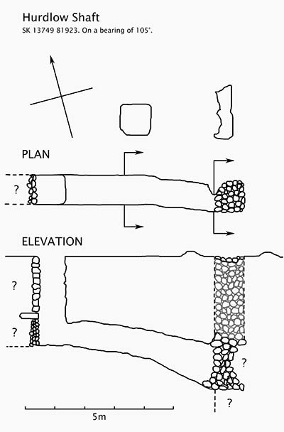
Phil - the detectors were recovered one month after the dye was injected. This was due to mega flooding throughout the intervening period (and of course the annoying distraction of earning a living!). So we have no flow through times I'm afraid. By the way, only a relatively small amount of dye was injected because we fully expected the water to turn up in one of the tiny inlets in Stemple Highway. Even though there was a big dilution the detector in Far Sump from just downstream of the entry of the main feeder was convincingly positive.
The reference for this test is CDG Newsletter 79 (April 1986) page 12 & 13. Incidentally the positive trace from Far Sump to Main Stream Inlet, confirming the presence of an unknown outlet in Far Sump, is also detailed in this reference.
Given that dye from that mine shaft turned up at the main feeder in Far Sump - as did dye from the Western Dig (i.e. 2nd shaft) at Titan - that mine shaft just possibly might offer a way into the hypothesised great western railway tunnel which the Titan dig was trying to access.
And below is the 'survey' of the shaft, such as it is:
Pitlamp
Well-known member
Excellent - that saves me looking it up!
All I would say is that a single test, unreplicated - and having used only a tiny amount of tracer - shouldn't be considered 100% reliable. But at least the information's there for folk to make what they want of it.
The main reason that test was done was because we were looking upwards in Far Sump Extension at the time, trying to work out how t'owd man had got in there. Speedwell was the main contender but there was always a chance of a surface mine shaft having dropped in. It would be a further decade before the non diving link (via JH) would be achieved, immediately removing the all pervading sense of remoteness which used to be very apparent in far Sump Extension.
Just for completeness, we also tested the stream which sinks into the choke at the bottom of the 30 m deep Vortex 3 shaft in the high levels - expecting it to emerge from Stemple Highway Inlet Sump 1 - but we lost the dye. (SHIS1 was a sump of course in those days, until the JH stream was diverted down the Boulder Piles. It's hard to imagine when you pass through that gritty dry crawl nowadays.
It's just dawned on me that mine shaft test in the triangular field was 30 years ago. Blimey, how time flies . . . .")
All I would say is that a single test, unreplicated - and having used only a tiny amount of tracer - shouldn't be considered 100% reliable. But at least the information's there for folk to make what they want of it.
The main reason that test was done was because we were looking upwards in Far Sump Extension at the time, trying to work out how t'owd man had got in there. Speedwell was the main contender but there was always a chance of a surface mine shaft having dropped in. It would be a further decade before the non diving link (via JH) would be achieved, immediately removing the all pervading sense of remoteness which used to be very apparent in far Sump Extension.
Just for completeness, we also tested the stream which sinks into the choke at the bottom of the 30 m deep Vortex 3 shaft in the high levels - expecting it to emerge from Stemple Highway Inlet Sump 1 - but we lost the dye. (SHIS1 was a sump of course in those days, until the JH stream was diverted down the Boulder Piles. It's hard to imagine when you pass through that gritty dry crawl nowadays.
It's just dawned on me that mine shaft test in the triangular field was 30 years ago. Blimey, how time flies . . . .
Rob
Well-known member
Do you remember where your detectors were? I'm guessing you put them in downstream end of Far Sump and Speedwell somewhere, plus possibly MSI? If neither of those were positive that does pose an interesting puzzle!Pitlamp said:Just for completeness, we also tested the stream which sinks into the choke at the bottom of the 30 m deep Vortex 3 shaft in the high levels - expecting it to emerge from Stemple Highway Inlet Sump 1 - but we lost the dye....
Pitlamp
Well-known member
Sorry Rob - because we were "certain" that the Vortex 3 stream was that which used to emerge from Stemple Highway Inlet Sump 1 we only put detectors into the Stemple Highway Inlet Sump 1 stream.
They were the only two decent flowing streams in that area; although Vortex 3 is considerably higher, it's very close in plan view. So this test was more of an afterthought to confirm our suspicions. As is often the case though, our suspicions were probably wrong (bearing in mind that absence of evidence isn't evidence of absence). I remember we contemplated repeating this test in a more comprehensive way (i.e. with detectors all over the system) but the hunt for the dry way into Far Sump Extension then evolved to the stage where a further test wasn't needed.
Nowadays of course we know that both Stemple Highway Inlet Sumps 1 & 2 are dry whilst Vortex 3 still has water showering down it, so one thing we can say with genuine certainty is that Vortex 3 does NOT go to Stemple Highway Inlet Sump 1 (at least in normal discharge conditions). It may go to the inlet in Far Sump concealed behind a mud bank about 240 m in from the downstream end of the sump. But then again . . . . ;-)
One of the things I want to do at "some stage" is go through my caving diaries and list details of all tests done in the Peak System, as this would perhaps be useful to other cavers. If the move to revamp the BCRA Hydrology Group is successful - and if a water tracing database is set up (as hoped) - this would give me the motivation to push it higher up the immense "to do" list which I never seem to get on top of.
Speaking of the Hydrology Group initiative, there is to be a brief discussion on this during the Malham weekend in May, with a view to setting up a separate gathering purely to progress the initiative (maybe during that Eurofest thing at the Dalesbridge Centre in August, when many people will be together).
pwhole
Well-known member
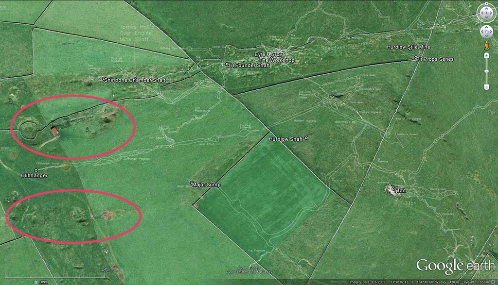
Here's the relevant area in GE - it does strike me that the unknown mine workings at bottom left could possibly percolate or drain into the Major Sump area. We've also managed to make the small choked inlet at the base of JH West (the formerly-flooded cartgate) into a sizeable flow in wet weather now. This is the one that was originally used to input dye for the Boulder Piles test. We don't have any idea as yet where that comes from as it's got quite a pressure to it and is welling upwards as well as eastwards. It's very close to Main Rising in plan, but 150m above it. It's possible the large doline used as a pond in mining times (with the little stone bridge you walk over on the way to the shaft) is the source of this water, but another test could be done around here.
Nettle is the next significant known cave feature west, but water at the bottom of that would be far too low to come in here - though water running along the Far Flats might. It's just as likely to be from Horsepit Rake workings in Linacre though. We may even manage to solve the cow-arse worms issue at the same time. I popped into the Leviathan end of the former sump a fortnight ago, but it looked as though someone had recently been through as it was all stirred up and the worms couldn't be seen. However, the stink was as horrible as ever...
Nettle is the next significant known cave feature west, but water at the bottom of that would be far too low to come in here - though water running along the Far Flats might. It's just as likely to be from Horsepit Rake workings in Linacre though. We may even manage to solve the cow-arse worms issue at the same time. I popped into the Leviathan end of the former sump a fortnight ago, but it looked as though someone had recently been through as it was all stirred up and the worms couldn't be seen. However, the stink was as horrible as ever...
RichardB1983
Member
Always interesting to see how features underground relate to features on the surface.
Out of interest: where do you get the GE overlays used to display this?
E.g. there are several conspicuous lines of shakeholes visible heading west - a couple in the direction of Eldon Quarry, and one heading directly for P8. Do these have any bearing on underground features?
Out of interest: where do you get the GE overlays used to display this?
E.g. there are several conspicuous lines of shakeholes visible heading west - a couple in the direction of Eldon Quarry, and one heading directly for P8. Do these have any bearing on underground features?
Mrs Trellis
Well-known member
Stunning graphic.
pwhole
Well-known member
Out of interest: where do you get the GE overlays used to display this?
John Beck, as always. No longer sadly
I revised it slightly to show the areas west that interest me, all former (but unnamed) mine workings.
