Peak pontification (split from Rowter Hole Update)

pwhole

Well-known member
Our dye traces from Longcliffe Mine, Son of Longcliffe and the Cowlow Nick wet-weather sink all proved an alternative route to the resurgences some 400m north of the Speedwell streamway - indeed this water may join the water from Blue John and Treak Cliff Caverns (and potentially some of the water from Rowter Hole and Winnats Head Cave) en-route. It's my contention (with no further solid evidence so far), that there is another streamway, parallel to the Speedwell streamway, but close to the shale boundary, and running under Goosehill Hall. I also suspect some sort of relationship between WHC, the Halfway House Series in Speedwell, and the Longcliffe system, although there's little evidence of any vadose development in Longcliffe - it's all hypogenic/phreatic at the bottom end, and I suspect the current stream that flows through is relatively modern.

Of particular interest was the tracing output from Peakshole Sough, originally driven to de-water the Longcliffe mines, but abandoned just over halfway to its goal - it's generally understood that the abandonment was due to poor ore returns in the thin vein they were following, and they were consequently unable to afford further driveage. However it's also possible that the knowledge that the mine/cave system was essentially self-draining may have persuaded the owners to give it up as pointless. What's really interesting though is that the water actually rises from the floor of the level only about 20m inside the entrance. Even more interesting is that the detection times were the same, but whilst the dye from PS was very concentrated, RW and SM were very weak. This strongly suggests a 'mixing chamber' beneath the slope of Goosehill, where all these flows converge before resurging.

We do plan to repeat all these traces after further work to try and improve the drainage from SoL, as the outlet for the water is very small, and regularly sumps the lower passage in wet weather - although it always does drain away. But given that's perched far higher than any known streamway, and given the speed of travel, it suggests a vertical system of some sort nearby, and probably underneath the Speedwell Vent. None of the Longcliffe ore accounts I've seen explicitly mention known watercourses, but one reference does mention two guys being paid for 'driving in swallo'.
 
Last edited:

pwhole

Well-known member
Here's a few shots of some of the interesting surface features in the field to the west of the Rowter Hole shaft, but east of the track. That walk was worth the access fee ;)

IMG_20230331_154605_HDR.jpg


IMG_20230331_154810_HDR.jpg


IMG_20230331_160420_HDR.jpg


IMG_20230331_154656_HDR.jpg


IMG_20230331_160353_HDR.jpg


This feature is way over to the east, nearer to the Pilkington's shaft on Faucet Rake, but off the vein line and closer to the head of the Cowlow Nick gully - a possible old swallet when the shale margin was at the top pf the reef rather than the bottom? Looks a bit like a worn -out version of the P8 entrance.

IMG_20230331_163120_HDR.jpg


IMG_20230331_163045_HDR.jpg


IMG_20230331_163033_HDR.jpg
 

Mrs Trellis

Well-known member
One thing that's struck me about Rowter is t'owd man obviously knew where the large cavern was that they sunk the shaft into. Was this shaft a hauling shaft? If so did the mine pay dividends to cover the expense of sinking a deep shaft through solid limestone?
 

Boy Engineer

Active member
Here's a few shots of some of the interesting surface features in the field to the west of the Rowter Hole shaft, but east of the track. That walk was worth the access fee ;)

View attachment 17703

View attachment 17704

View attachment 17705

View attachment 17706

View attachment 17707

This feature is way over to the east, nearer to the Pilkington's shaft on Faucet Rake, but off the vein line and closer to the head of the Cowlow Nick gully - a possible old swallet when the shale margin was at the top pf the reef rather than the bottom? Looks a bit like a worn -out version of the P8 entrance.

View attachment 17708

View attachment 17709

View attachment 17710
Has the feature on Photo 3 ever been dug?
 

pwhole

Well-known member
Not that I know of, but I'd like to (or someone) have a go - we did discuss approaching the farm about it, suitably fenced-off of course, but it's another on the 'to do' list! The collapse on Shackhole Scrin itself nearer the engine shaft could also be checked out, though I believe Moose did have a look at it some years ago and didn't think much of it.

It's generally believed that Joseph Clay of Bridgehouses in Sheffield was the main owner of Rowter Hole ('Mr. Clay's Engine') during its heyday, and he was loaded - he had interests in lead, iron/steel and coal, and so it's likely he was able to chuck a bit of money at a project if it looked viable. But I agree, it seems the miners certainly knew about the natural in there already, as that shaft is so precisely driven into the roof of the vein cavity.

If you go upslope from the shaft base (eastwards), and then up the next rope into the upper chamber (which is seriously impressive BTW), and then walk up to the top of that steep slope, you can climb up into a messy area of semi-collapse, with what appears to be the remains of a miner's staircase coming down from above. It's likely that it was a climbing shaft from surface.
 

pwhole

Well-known member
Google Earth screenshot showing the main veins, cave entrances and the Peak-Speedwell system. Note the how far south the Speedwell streamway is compared to the amount of limestone to the north with 'ambiguous' drainage, and Blue John and Treak Cliff aren't even visible. We know Faucet Rake at least partially drains into Whirlpool (as clearly shown on the survey east of RH), but further north of that it gets less certain, and there are hundreds of metres of limestone until the shale boundary - and the limestone continues beneath it of course. Suicide Cave clearly continues under the Winnats Road, and is roughly at the level of the Halfway House and lower Longcliffe passages, suggesting a large phreatic system that must have drained elsewhere than the Speedwell streamway. Longcliffe definitely doesn't drain into Speedwell. Also you can draw a straight line from Victoria Aven to Winnats Head Cave through quite a lot of interesting features en-route.

MainVeins.jpg
 

Mrs Trellis

Well-known member
Suicide Cave clearly continues under the Winnats Road, and is roughly at the level of the Halfway House and lower Longcliffe passages, suggesting a large phreatic system that must have drained elsewhere than the Speedwell streamway.
There's an obvious choked hole on the south side of the road , west of the cattle grid.
 
Has anyone got a positive dye trace to the bricked off natural at the bottom of the steps in Speedwell? It's a tiny passage that only ever flows in very high water but issues quite a volume of clay brown water when it does. We always surmised it came from Blue John or Treak Cliff.
 

pwhole

Well-known member
It could come from Suicide Cave for sure - the place is always bone-dry in the accessible portion, and the main passage line is heading straight across the road toward the showcave. Whether Treak Cliff partially drains into Suicide (below the accessible portion) I have no idea, but it would make sense for there to be some sort of a connection somewhere. I had a look at the bottom of the new Treak Cliff extensions with MartinB last year, and the water certainly drained away at the base easily enough, but my feeling is that some of this water may drain straight down the hill to resurge on the shale in the field below - I don't know if anyone's ever had a look down there but it looks a bit funky near the trees.
 

alastairgott

Well-known member
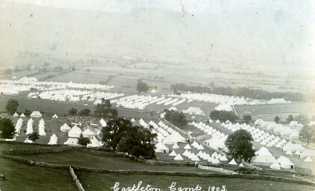
1905_castleton.jpg
I read somewhere (and now I’ve tried to find it again) that there was a bomb dropped in the war on the slopes underneath treak cliff on the opposite side of the road. I’ve checked out the historical society but it’s not there https://chstrial.files.wordpress.com/2016/10/some-castleton-history.pdf
I’m sure I’ll find it, but the location I’m fairly certain is here
Dropped pin

Off topic, The only reason I’ve put this up is pwhole reference to “down the hill to resurge on the shale in the field below - I don't know if anyone's ever had a look down there but it looks a bit funky near the trees”

If pwhole is referring to this area
Dropped pin
https://goo.gl/maps/VxrKYMhD3G9tS9oH9 there is evidence of human involvement here, from memory- walls and something like an organised garden, unless I’m remembering something that wasn’t there.

On the subject of totally unrelated things - the Great War camp https://derbyshireterritorials.files.wordpress.com/2013/09/1905_castleton.jpg
 
Last edited:

SamT

Moderator
Indeed, it was dropped from a German plane that I believe had been shot over manchester somewhere and was jettisoning its payload in case it came down (wise). I never found out whether it did make it back to Germany or indeed crash landed somewhere
And its here... https://maps.app.goo.gl/9xMnAwePA9fR45197 note the very regular circular smooth crater like walls.
 

SamT

Moderator
Not sure this has been mentioned before, but the far end of Hypothermia passage ends in a Shackhole Scrin for sure. Pokey place to be digging through a choke, but could yeild access to the continuation of shackhole scrin towards Longcliffe?
 

pwhole

Well-known member
I've always been intrigued as to the 'missing' central portion of Shackhole Scrin - or at least any surface indications, but I can't imagine the vein just stops and starts again, though I guess geology isn't an exact thing. The Google Earth image shows the bit I mean arrowed. The engine shaft we dye-traced is labelled as '1'. There's also the small vein in-between that and Faucet Rake that I've labelled '2', which doesn't have a name as far as I know. It may be nothing, but who knows around there? Also some of the shaft hillocks around where the Assault Course ends are enormous, and well off the main vein line - I've often wondered why this is so. They don't seem to have any accessible holes in them though. I've never been to the top of the Assault Course pitches, but I don't remember reading about any shafts coming in from surface there.

After the Google Earth image is a view from the Rowter shaft looking immediately west, then the large hillocks looking west, and then a shot from the hillocks showing Faucet Rake, the mystery vein in the centre and Shackhole Scrin in the distance, skimming the edge of Winnats Pass. Goydenman, didn't you once tell me you went exploring in the pass side below this area with Ben Bentham?

Finally, slight unrelated to Rowter, but the Bottomless Pit in Speedwell is always 40m south of the surface workings on Faucet Rake on any survey, even our most recent. Yet it's meant to be on the rake, and the vein has no obvious hade underground, but it never matches the surface. But the west end of Pit Top Passage hits the end of a smaller branch vein on surface, and the choke at the end has both vein material and flowstone blocks in it. I'd love to have a go at bringing that down, as it could be another link to the Pilkington's area. Or into Rock Pipe. And it's over 60m from the lip of the passage down to the visitor platform, so zero danger to them, and more than likely would improve the ventilation! I may start politely pestering JH for a trial poke ;)

ShackholeScrin.jpg


_IGP0061.jpg


_IGP0069.jpg


_IGP0068.jpg
 
Last edited:

T pot 2

Active member
The top climb of the assault course ends at a tube to the left, after 1.50 m a tight further left is encountered, i manged a left to right body manoeuvre to continue however with no-one watching my back i reversed out.
The only observation was it was draughting an hooly. I also saw other leads from the assault course one of which was a roof choke that was draughting to.
 
Top