Tying up some loose ends- P8, Eldon Hill & quarry, Slitherstones and beyond

Rob

Well-known member
bograt said:
Just been playing with the Survex, it appears that Sidetrack and Convenience are both on the same development horizon as Damocles rift, is this feasible? if so, 'Petras' would be on a lower horizon and could prove worthwhile....
Bograt, do you have Eldon Hole data on Survex, other than just the single line on the online version?
 

alastairgott

Well-known member
Bograt, afraid I can't get out on sunday, driving to south wales for the week via burton-upon-trent.

But i'll let you know how Saturday goes, and have fun on Sunday.
 

bograt

Active member
Rob said:
bograt said:
Just been playing with the Survex, it appears that Sidetrack and Convenience are both on the same development horizon as Damocles rift, is this feasible? if so, 'Petras' would be on a lower horizon and could prove worthwhile....
Bograt, do you have Eldon Hole data on Survex, other than just the single line on the online version?

No, just the online version, but you can get quite a bit of useful detail off it by zooming in.
 

bograt

Active member
Sit Rep;

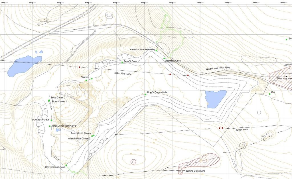
Went over for a 'memory jog' (the ony jogging I'm capable of now!) on Sunday, concluded that Petras is not a continuation of the hole I remember, still got to formulate all my ideas into some kind of theory.
They certainly 'raped' the place in the closing down stages and removed most of the landmarks I noted on the site visit, the only other caver there with me on that day was Mick Fish (RIP), don't know if he left any record?, sometime between '84 & '89?, it was a P.R. open day by the company trying to drum up support for extending operations from interested bodies.

I suspect that the hole has been filled in when they levelled the floor at closure;

I also have the impression that Sidetrack, Petras, and Conveniece are all intercepted passages from abandoned swallets, akin to Nettle, Mountbatten, Thistle, Eldon, etc., accumulating in the vicinity of the quarry and descending into the 'Main Drain' - water flow marks from scallops would confirm or defeat this conjecture.

I estimate the thickness of coarse backfill on the bottom (and only remaining) terrace to be around 2-3m average, this is the thickness of loose stuff we have to detect through to map the bed rock and find a void filled with loose stuff----?? Geotech? (sonar, x-ray, resistivity?) I'm sure others here will have the expertise and experience of temperature differentials etc. to advise whether heat detection is viable through this depth, and in what conditions.

I also noted a few other observations;

1. All the faces on the West side of the quarry show signs of excessive shattering, this is often an indication of charging explosives into a non-solid void, causing uncontrolled blasting, as evidenced by a number of glacial filled cavities in this area, this is also noticeable to the West end of the top terrace of the Northern face, (Sidetrack terrace), I doubt that these would yield much length or depth but maybe some worthwhile decorations, in fact, if you look closely at some of the clay-filled orifices in the West face, there are some atmospherically deteriorated formations visible.

2. Most of the cave development on the North and South of the backfilled bench is rift developement ( also akin to Nettle, Eldon et.al).

3. A lot of water seepage about halfway up the bottom face of the Northern side, this appears to be displaced between Sidetrack and Petras, need to determine which developement horizon this is on, maybe the Flats in Nettle? -- research needed, also, how does this relate to Eldon & Giants/P8??.

4. Water seems to disappear, evidence of sygnificant drainage from the small grain gravel heaps at the Western end and various beddings around the quarry, has anyone noticed variations in the level of the mere in the East end? (This suggests that if it is found, digging in backfilled small gravel that has been washed in will be required).

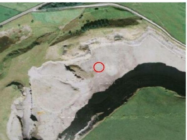
5. A noticeable inconsistency in the vegetation and levelness in the area of the 'red circle' on my map. I would be loathe to suggest anything until further research is carried out.


They are my observations, that is what it is, comments please? we buried my chief mentor last week, and I'm missing him like h*ll, anyone like to take on the role?

Its a great pity Prof. T.D.Ford is unable to provide more protege's ------ :cry:


P.S., apologies for the longevity, but I hope someone will read it through and add something constructive.
 

pwhole

Well-known member
As far as I remember, the flats in Nettle are at the same horizon/bedding as the top of Eldon Hole. And for what it's worth, I'm presently trying to extract as much as is (politely) possible from Trevor and his previous proteges... ;)
 

AR

Well-known member
bograt said:
I estimate the thickness of coarse backfill on the bottom (and only remaining) terrace to be around 2-3m average, this is the thickness of loose stuff we have to detect through to map the bed rock and find a void filled with loose stuff----?? Geotech? (sonar, x-ray, resistivity?) I'm sure others here will have the expertise and experience of temperature differentials etc. to advise whether heat detection is viable through this depth, and in what conditions.

Two geophysical techniques I know of _may_ work. Firstly, Ground Penetrating Radar (GPR) could theoretically detect the bedrock under the loose and show up any changes in this, put from recollection 2-3m is pushing the limits of detection and rocky soils tend to scatter the signal. Secondly, there's microgravity which can be used to detect buried voids but I don't know what its sensitivity is like.
 

AR

Well-known member
Going back to something mentioned on a previous thread, namely overlaying the old OS onto Google Earth, I've had a quick look and this is putting the old mine shaft as being on the upper bench of the north face approximately 160m from the western end.
 

bograt

Active member
Seems like a job for uni. departments and BGS., any contacts? 

Otherwise its up to us amateurs to sort it out, I recall the tale of Mr. P.B. telling me about some sort of research programme by Dr. Lord detecting a significant void in the approximate area of Titan, 45 years (maybe more?) -- before technology ( and Moose) discovered it, this is the reason for 'Shod Pot' (if irc) -  (BSA records?)

Think it was Seismology or summat.
 

pwhole

Well-known member
A mate of mine has just gone back to Iraq today, working with oil-prospecting teams. They're mostly using passive GeoPhys detectors laid in huge grids on the surface. When the ground is unsuitable for passive techniques, they're using explosives to trace voids and deposits - similar to sonar, they're filtering out the default 'bang' and are reading the irregularities within the scan. He says this method works down to about 1.5km depth, but I've no idea how big the charges are.
 

braveduck

Active member
Looking for a shaft which is shallower than Oil some thing simpler would do.
I believe a sledge hammer striking a  metal plate on the ground should produce a suitable
seismic wave .You just need to collect and process that seismic wave !
In my experience looking for voids under old quarry floors is not that hard .
Good eyesight .Floor with no voids is solid ,but where there is a void, fines and dust wash through
leaving black spaces however small.
Try low teck first ,high teck later . When you have located a possible spot you then need snow
and then magic smoke in a can .Hope this helps.
 

Mark R

Well-known member
braveduck said:
I believe a sledge hammer striking a  metal plate on the ground should produce a suitable
seismic wave .You just need to collect and process that seismic wave !

As part of a geophysics module when studying at Liverpool we undertook some small scale seismics on a field outside the department by whacking a thick perspex plate with a sledge hammer and laying out geophones across the ground. It produced some results but how useful the data would be I have no idea, it was a while ago now.
If someone was really keen I'm sure that by contacting some universities through the correct channels they could be convinced to conduct these small scale seismic demonstrations/ practical experiments somewhere of interest to cavers.

I'm not really keen though :)

M
 

bograt

Active member
Been doing on line research into these suggestions and I'm of the opinion, knowing the place, that small scale seismology is probably the way, maybe using caps as a consistent shock generator?
Now all we need is a dozen geophones and some means of recording and interpreting the data :-\
 
I did a similar thing for my geology degree; hitting a metal plate with a sledgehammer with some geophones down to map some old ruins under the grass outside Manchester Uni.  I actually work in the site investigation business but for offshore works and unfortunately not the geophysical side either.

If someone was really interested I know a couple of people I could tap up for some advice / suggestions.
 

bograt

Active member
MJenkinson said:
If someone was really interested I know a couple of people I could tap up for some advice / suggestions.

I suppose this comes down to the OP, Alistair, I am quite interested, but do not have the time or ability to be really interested, hence my mainly sedentary research.
 

Rob

Well-known member
bograt said:
Couldn't do anything with Google maps, probably a combination of steam driven computer and alcohol pickled cerebrum.
Had to go for screen grab, sorry about the quality but should give you some idea of the location as I vaguely remember it, around the red circle;

169774c3-8c91-4087-9f48-02af1312b05f_zpsfq53mjzg.jpg

...

To add some caution to this exploration attempt, i believe the area highlighted by the red circle has varying depths of fine gravel, which is bound to add another level of complexity to the data analysis. These shots from a few years ago are very near there:
s_Oc1qxyG56pRhdO-HIArCwcJoTQBOh0bhgscq44UWu1jSjNcWHX8KhcUECmkaqTK5X-tecmNlhPwBg=w2560-h1547


-r2bGDabJMC969EiNfxOlgQ7uNrLQTgfkCisv83kuVfpVplmon87CG4pEh2TQjou0D7bwox6IVJMCyw=w2560-h1547


Additionally the 2013 DCA survey of Eldon Quarry shows no features in that area:
l-FVeaw1jMd5dgWHJp2hjoBg2jFpIezakCfM1EzCF-bUcImkqqtqj43ECtqanvOID0Sxe2pp0qgMZ6E=w2560-h1547


Not withstanding this, if someone is keen to pursue it would be great if it works!
 

bograt

Active member
Rob said:
..
These shots from a few years ago are very near there:
s_Oc1qxyG56pRhdO-HIArCwcJoTQBOh0bhgscq44UWu1jSjNcWHX8KhcUECmkaqTK5X-tecmNlhPwBg=w2560-h1547


Additionally the 2013 DCA survey of Eldon Quarry shows no features in that area:

Not withstanding this, if someone is keen to pursue it would be great if it works!

Sorry, Rob, can't get your images up.

Re; The DCA survey, this was made years after the quarry floor was levelled with varying grades of gravel, my memory of around 30 years ago was based on what I saw on the bare rock quarry bench, I appreciate the problem with data interpretation, hence the request for more expert advice,--- positivity is the watchword  (y) (y)
 

alastairgott

Well-known member
Hi mr jenkinson,

Yes, certainly Very interested in seeing what we can do in some of derbyshire's quarries.

Very high potential in eldon quarry and also railway sidings quarry, south east of wormhill.

We need a quarry cave like cwm dwr in wales but closer to home :) we've already got some lovely pretty caves in eldon quarry, but there's always room for more like them.
 

braveduck

Active member
Try contacting Mike Bottomley  of CPC I believe he is an expert at seismic surveys .
He may be able to help.
 

Rob

Well-known member
bograt said:
Sorry, Rob, can't get your images up.
Here's another go...

To add some caution to this exploration attempt, i believe the area highlighted by the red circle has varying depths of fine gravel, which is bound to add another level of complexity to the data analysis. These shots from a few years ago are very near there:

Eldon1_zps9x2uu0ko.jpg


Eldon2_zpslx2kewof.jpg


Additionally the 2013 DCA survey of Eldon Quarry shows no features in that area:
Eldon3_zpsleejp6gi.jpg


Not withstanding this, if someone is keen to pursue it would be great if it works!
 

bograt

Active member
Rob said:
bograt said:
Sorry, Rob, can't get your images up.
Here's another go...

To add some caution to this exploration attempt, i believe the area highlighted by the red circle has varying depths of fine gravel, which is bound to add another level of complexity to the data analysis. These shots from a few years ago are very near there:

Eldon1_zps9x2uu0ko.jpg


Eldon2_zpslx2kewof.jpg


Additionally the 2013 DCA survey of Eldon Quarry shows no features in that area:
Eldon3_zpsleejp6gi.jpg


Not withstanding this, if someone is keen to pursue it would be great if it works!

Thanks Rob, draw a line between Sidetrack/Alsops and Convenience, another between Petras and Alders dream, the intersection will be around the green patch in your second picture? (within the "red Circle"?)

I suspect that flow details in Petras, Alders dream, Sidetrack / Alsops, and Convenience will all show an outward trend? awaiting confirmation -- .
 
Top