Tying up some loose ends- P8, Eldon Hill & quarry, Slitherstones and beyond

Big Jim

Member
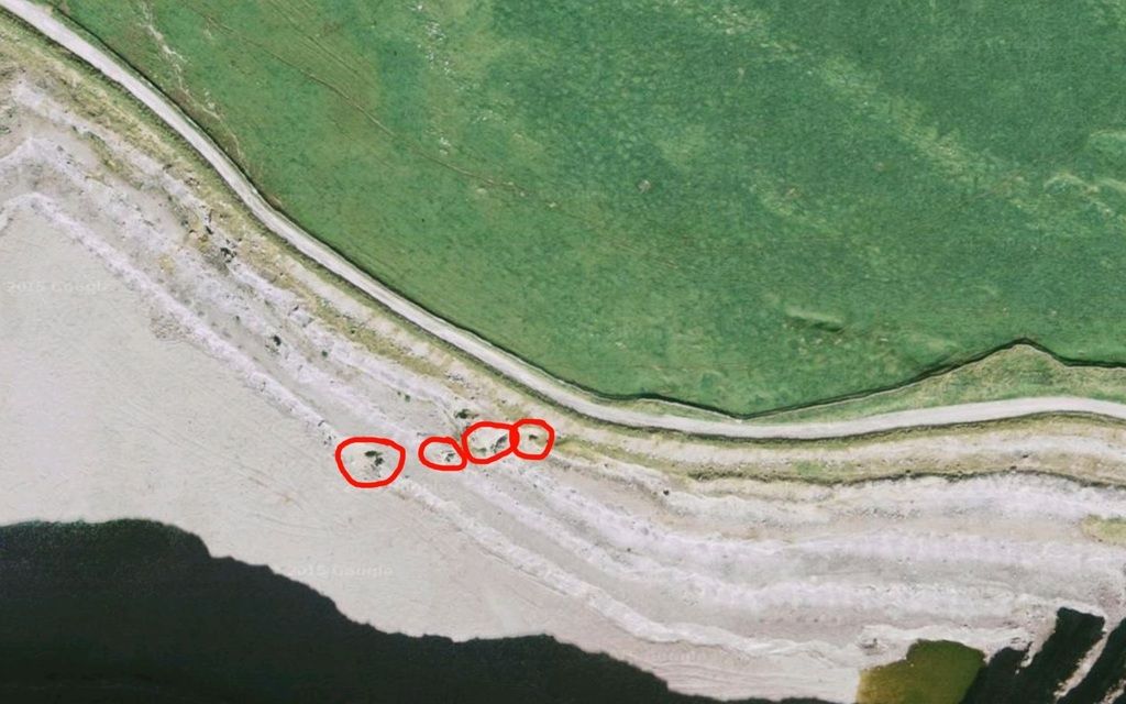
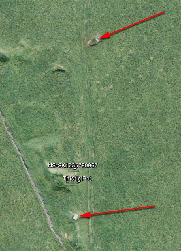
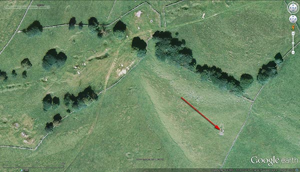
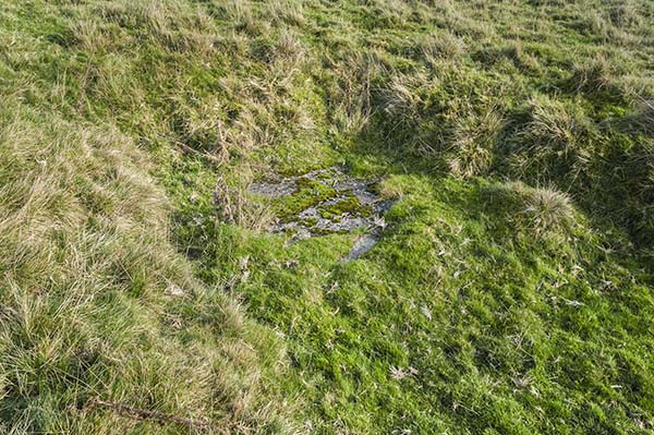
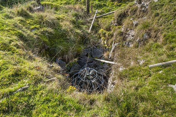
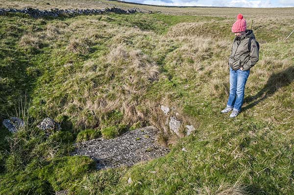
Talking of thistle pot..... a few of us had a look at that about 5 yrs ago. Its got a Clwyd cap on now  but we did some late night exploration and had the cap off. Martin Grayson descended on a couple of trips and he hauled out a few large chunks of rock but Martin didn't seem that keen on pursuing it, but anyone interested in this would be wise to ask Martin what its like now. We also had a look at the deep winding shaft about 50 yrds away with the gin circle and half centre stone that has a 8ft square grill over - this went to about 60m depth with no levels off and was blind but we assume infilled as Martin said there were deep rope grooves from hauling only a few feet from the bottom. Alas on a 2nd trip during the first credit crunch we got caught by farmers wife whilst 2 suss members were down the bottom having a poke and got an ear full.  :confused:
 

Rob

Well-known member
Looks like some obvious features in that area on Google Earth:
Eldon4_zpsfmsduv3v.jpg


These seem to be on the Eldon End Mine / Windle and Rush Mine vein, so may not in fact be shafts, rather just weaknesses that led to localised collapses in the quarry face. Either way they should be able to accurately pinpoint the vein on the surface, and hence locate any mine shafts...
 

Madness

New member
Rob said:
Looks like some obvious features in that area on Google Earth:
Eldon4_zpsfmsduv3v.jpg


These seem to be on the Eldon End Mine / Windle and Rush Mine vein, so may not in fact be shafts, rather just weaknesses that led to localised collapses in the quarry face. Either way they should be able to accurately pinpoint the vein on the surface, and hence locate any mine shafts...

If the shaft was capped rather than filled could it not be possible to dig horizontally along the vein from the quarry face to intersect the shaft?
Assuming of course the shaft is on the vein.
 

AR

Well-known member
Or you could instead re-open the engine shaft that's under one of the red circles.....
 

pwhole

Well-known member
I'm afraid I don't have a contact for Peter Lord, otherwise I would have been bugging him a hell of a lot by now ;)

Someone must know - I have a feeling Jim R had mentioned he might be in Australia.
 

Mark

Well-known member
pwhole said:
I'm afraid I don't have a contact for Peter Lord, otherwise I would have been bugging him a hell of a lot by now ;)

Someone must know - I have a feeling Jim R had mentioned he might be in Australia.

Last I heard he was in Canada
 

AR

Well-known member
Apologies Phil, I know someone managed to get in contact with him, now you've said it's not you I think I know who it might have been and I'll be seeing him tomorrow night....
 

pwhole

Well-known member
Whilst we're on the subject of Thistle, does anyone know the provenance of the two shafts nearby, and which appear to be on a North-South vein unconnected with the other vein trends in that area? Illustrated below.

Thistle_Aerial_crop.jpg


There's also a shaft on the north flank of Conies Dale, just SE of Watts/Jowle Grove on a small vein that crosses the small dry valley which must have been looked at before, but is in an interesting location - it looks choked a few metres down, but is open:

ShaftnearWatts_sm.jpg


AR

Well-known member
OK, having spoken to Steve Thompson, he tried to get in touch with Peter Lord through Facebook (he's in Mexico, apparently) but got no response. However, Steve did say that he recalled something about the Slitherstones area finding its way into a SUSS journal and also that Geoff Workman may have published something prior to that.
 

alastairgott

Well-known member
Incidentaly chris talks of a mine called 'wall in the dale' which is visible on the map i posted on the 26th, with the wall intact. But the wall has been wiped-out since.
 

pwhole

Well-known member
Here's surface shots of the two shafts I mentioned with the aerial photo, with the Thistle cap betwixt them, in case they jog any memories:

_IGP7865_sm.jpg


_IGP7866_sm.jpg


_IGP7868_sm.jpg


alastairgott

Well-known member
I have opened another thread, to split off any discussion about windle and rush mines.
http://ukcaving.com/board/index.php?topic=18099.msg236115#msg236115

I think i might abort on the halfbaked plans for geosurveying and heat detection, and plumb for the derbyshire technique- follow the mines...

I still think that perhaps it would still be an idea to do some of the geo-whatsitting and that, but i guess more out of interest than anything so i guess i ought to state that now. So that mr jenkinson and other people don't put a lot of work in trying to find people.
 

Big Jim

Member
Re the image Mark kindly posted for me cos Im a feckin retard at this shit..........  The shaft I mentioned previously is marked to south of Thistle - winding shaft with gin circle covered in large grill. Think it was about 60m deep and blind but with deep grooves (from hauling) in wall only feet from bottom so must go deeper. Should still be possible to get down this one as the grill is in sections and a couple of the welded on bolts mysteriously got cut off and replaced with normal bolts;-) Martin Grayson (TSG) went down and latterly Ali Gaybar and H from SUSS had a poke at bottom but we got caught by the farmers wife.

The area circled to north of thistle looks like a run in shaft with a bit of old fencing around it - me n Grayson had a quick look but ended up rescuing a lamb that was stuck down there.

Has anyone been down the other shafts on windle/rush vein - there are a couple more big shafts to the west of the one Ive circled????
 
Top