

You are using an out of date browser. It may not display this or other websites correctly.
You should upgrade or use an alternative browser.
You should upgrade or use an alternative browser.
Wezzit?
- Thread starter mikem
- Start date
Pitlamp
Well-known member
I've never come across badgers that could chew through bedrock Fjell.
Well done GrahamS; all yours.
Although entry at this point seems unlikely, the resurgence is of significance. It's probably the stream which is recorded as being heard rumbling at Robin Hood's Mill further up the field. There's what looks like a fault guided valley running WSW up the hillside behind RHM for a considerable distance. It would be interesting to re-investigate RHM but never been sure who farms that field to ask for permission.
I think the last time it was dug was getting on for a Century ago (early 1930s) and it was evidently inconclusive. Cavers didn't need to be quite so persistent in those days as there was still loads of wide open stuff to be had. There's some useful detail in Albert Mitchell's book "Yorkshire Caves and Potholes; North Ribblesdale" (1948 reprint), pages 10 & 11.
alanw
Well-known member
Shown up beautifully on the LIDAR imageThere's what looks like a fault guided valley running WSW up the hillside behind RHM for a considerable distance.
Mr Dinwiddy
Member
Sorry to divert from Wezzit......Although entry at this point seems unlikely, the resurgence is of significance. It's probably the stream which is recorded as being heard rumbling at Robin Hood's Mill further up the field. There's what looks like a fault guided valley running WSW up the hillside behind RHM for a considerable distance. It would be interesting to re-investigate RHM but never been sure who farms that field to ask for permission.
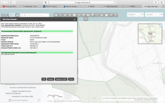
Its easy to look up who farmers are on Magic GIS- if they have an agri-environment scheme.
All the land to the north of that valley is farmed by H&M Dugdale and Son, Settle. See attached map screen shotted from Magic. Drop that business name into a mapping search and it gives you Borrins Farm Stackhouse Lane, Settle.
The farm wraps around the land to the south of the valley (hatched green on the map) and there is a field there which isn't within an agri-environment scheme so not so simple to find out who farms it. Happy to PM more maps if that helps.
Attachments
Thanks for exhibiting admirable restraint Pitlamp.That’s an excellent clue. (Keeping my gob shut on this one.)
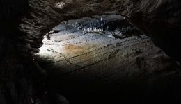
That's the exact spot Tobyk. Known as the Pool of Reflections if I remember correctly.Ingleborough cave? Near the end of the show cave before heading into the ‘wild’ bit
The clue is one for the oldies on here. Before Ingleborough Cave gained its electric lighting, visitors were given three candles on a stick and the guide had a hurricane lamp. The thanks for Pitlamp's restraint in not giving the location away, is a further clue as he has the best job in the world at the Cave.I would humbly like to ask for a clue explanation!
