A question about Grey Wife Sike on Ingleborough

Pitlamp

Well-known member
My final post of four, on today's investigations; this photo of the P1 shakehole is taken looking ESE. The far horizon is beyond the large Cote Gill valley and you can just see a building with some trees to the right of it. That's Knowe Gap (marked on the 1:25,000 map). This is adjacent to that other great drainage project called Knowe Gap Sike (but that's a different story). If you draw a line on the map from the P1 shakehole, through Knowe Gap, you pretty much arrive at Moses Well in the next valley over (Clapdale). Also, the trend of this line almost exactly matches the direction of main faulting in the limestones of this part of Ingleborough, which is parallel with the North and South Craven faults not far away to the right (in this view). So it's entirely believable that any water sinking at P1 is probably guided along a fault, straight to Moses Well (and probably Cat Hole as well in flood conditions).

(The trees visible at extreme right in this photo are part of the obvious L shaped plantation shown on the map around SD737707.)

That's about all I can report which is of use from today. Next time I get chance I'll try and follow the branch ditch from the shooting hut down the fell and see if I can confirm where it leads to.

(Further note - I seem to be struggling to upload this final image, which is potentially of greater interest to cavers. I might have to send it to Badlad and ask if he can make it work!)
 

2xw

Active member
Post war, the government paid grants to try to make land like this useable for grazing and agriculture. Gamekeepers also did it to encourage Calluna dominance which is good for grouse. Might it be that they just wanted to drain a particular patch of ground into a convenient hole? Bog drainage ditches are normally in a curved "herringbone" shape.
 

Badlad

Administrator
Staff member
Here you go - sorry for the delay

wl
 

Pitlamp

Well-known member
Thanks very much for your help Badlad!

One other snippet which might be worth adding here; Charles Dracup's excellent article on the discovery of Newby Moss Pot (Gritstone Club Journal 1969, News Series No. 3 [published Autumn 1970] pages 3 - 8, plus fold out plan & elevation) states:

". . . we strolled across to Grey Wife Sike and the deep shakehole where it used to sink, named "P.2" by the Yorkshire Geological Society water tracers . . ."

The three words I've highlighted support the above idea that the Sike originally sank at Newby Moss Pot (P2) before being artificially diverted.
 

Pitlamp

Well-known member
2xw said:
Post war, the government paid grants to try to make land like this useable for grazing and agriculture. Gamekeepers also did it to encourage Calluna dominance which is good for grouse. Might it be that they just wanted to drain a particular patch of ground into a convenient hole? Bog drainage ditches are normally in a curved "herringbone" shape.

Thanks 2xw, yes, I'm sure you're right. I remember the "gripping" that went on when was a very young caver and assorted warnings of greater flood risk as a result. But Grey Wife Sike goes back much further than the post war times; it's shown draining into the P1 shakehole on maps from the late Victorian era.
 

Pitlamp

Well-known member
Another piece of the jigsaw; Grey Wife Sike is shown on the BGS mapping tool:

http://mapapps.bgs.ac.uk/geologyofbritain/home.html

(You have to keep zooming in until the geology disappears at large scale, when you then just get a land surface map with water courses marked on it.)

It shows Grey Wife Sike continuing beyond the P1 shakehole, all the way to and past Newby Cote. This adds weight to the idea that one of the branches of GWS did supply some of the buildings at Newby Cote.
 

grahams

Well-known member
Does the geological map show the water going beyond P1 via a sike? The line is straight, possible implying the that water has been tested to a spring near Newby Cote, or that it is an assumed drainage route. The same applies to Thack Pot Sike to Clapham Beck further east. Also, man-made watercourses appear to be denoted by a line with side flecks - this is very hard to see due to the colour scheme. The straight sections of line do not have these flecks.

The map also shows short water man-made courses in Cote Gill with no apparent reason for existence. Examination of these might throw some light on the question.

I've been racking what's left of my brain regarding our walkabout in the area a while back. I remember that we walked down from the NMP area into the bed of Cote Gill and onto the well defined track to a point about 1km NE of Newby Cote. On the way down we came across a sike lined by slate? slabs running across the Cote Gill slope.
 

Pitlamp

Well-known member
Thanks; I've never seen a slate-lined sike but I'll certainly keep my eyes open in future. I have memories of large (broken) half-round sections of earthenware pipe in another sike up the top end of Cote Gill, more to the east side (but that was probably part of Knowe Gap Sike).

On the image I viewed on that BGS resource, it was just a single blue line heading southwards then SSW, deflecting south west to the P1 shakehole but then continuing on southwards from there to Newby Cote. I'll send you a screen shot by PM. (Bit wary of posting it here as I'm not certain about the copyright situation).
 

grahams

Well-known member
The Soil Observatory map gives a slightly clearer view of the watercourses but doesn't quite match the BGS map. The URL is http://mapapps2.bgs.ac.uk/ukso/home.html

For even more hours of fascination and enjoyment, there's DEFRA's Magic Map with its hundreds of selectable layers which tell you everything you're ever going to want to know about our landscape. MM is particularly useful if you're in the process of buying a house as it contains info regarding flood risk and anything nasty (such as polluted land) which might be nearby. The URL for the introduction is https://magic.defra.gov.uk and https://magic.defra.gov.uk/MagicMap.aspx for the maps. There's lots of information regarding protected areas, limestone pavement orders and SSSIs to name but a few.
 

Pitlamp

Well-known member
Quick update - I've been in contact with David Johnson, who wrote that Ingleborough book referred to above. He's going to go and have another look at Grey Wife Sike, once the lockdown is eased. We may well learn more then.
 

Pitlamp

Well-known member
Have now had chance to walk the westerly branch of the ditch which leaves Grey Wife Sike near the shooting hut. It trends WSW diagonally down the fell side for about half a mile and leads to the 3-way Y-shaped wall junction at SD72597133 near Bleak Bank, where there's a gate. Just before reaching this wall / gate the ditch splits into two. Both branches go through the wall but are then impossible to trace (probably because the downhill side of the wall is cultivated land and will no doubt have been ploughed a lot since the ditches fell into disuse).

It seem likely the left hand (looking downhill) branch would have supplied Bleak Bank farm, as suggested in a post above. The likely destination of the right hand branch is difficult to work out but it's not impossible that it went to the hamlet of Cold Cotes. However, the steep road down to Cold Cotes from the "back road" above (i.e. from the original turnpike between Clapham & Ingleton) has a ditch alongside it with a stream flowing along it, even though conditions at the moment are very dry. So there must be a separate spring supplying this ditch, which would no doubt have been made use of as a water supply by dwellings in Cold Cotes.

Clearly, there's rather more to this old irrigation system than merely the single ditch shown on the 1:25,000 map.
 

Pitlamp

Well-known member
Just a bit of additional information, to try to complete the whole picture (and perhaps with a bonus of having speleological / hydrological interest?). If you go along the back road from Clapham to Ingleton, shortly before you reach the turn off down to Cold Cotes, there is a rising called Blindfield Well or Blind Spring (SD72127132). It's in a walled enclosure with a few small trees in it, directly opposite from the roadside boundary stone. The enclosure is on the right of the road (travelling Ingletonwards) not far before an isolated house on the left called Cod Bank Barn (a barn conversion at SD 72047143). Lots of readers will have driven past this many times without realising it's there. In the attached picture the actual rising is under a rusty steel sheet at lower right; Cod Bank Barn is visible on the left of the road in the distance.

This rising is the source of Goat Gap Sike, which often carries a considerable flow in wet conditions. The stream isn't obvious from the road because the stream is culverted in this area. However, its course is visible on the Google Earth image. I mention it in this topic because there is a hill between the rising and the hamlet of Cold Cotes, which might have made a diversion to supply Cold Cotes from Goat Gap Sike difficult. This may lend weight to the idea that a branch of Grey Wife Sike was once used to supplement the other (small) spring-fed trickle which flows alongside the road down to Cold Cotes, at times of shortage.
 

Attachments

  • BlindfieldWell_and_CodBankBarn.JPG
    BlindfieldWell_and_CodBankBarn.JPG
    3 MB · Views: 181

Pitlamp

Well-known member
Just to return to this topic, which we discussed at length during the very worst of the coronavirus restrictions - David Johnson has made two trips recently, to investigate the irrigation / drainage aspects associated with Grey Wife Sike. He's prepared the notes below, which I've reproduced here in their entirety. Cavers with no great interest in this topic in general may find item 5 worthy of consideration however.

I'd like to thank David for his time, effort and attention to detail on this one.

...

Field notes, Grey Wife Sike, 13 June 2020

1. the stream from Knoutberry Hole (SD73779 72960) to the shakehole at SD73708 72275 is a natural feature.

2. the manmade channel leaves the stream at SD73711 72325 at 457m AOD (image 81, looking south).

3. water flows within the channel up to SD73700 72333 (457m AOD).

4. it is joined by a modern grip at SD73688 72290 so the channel becomes wider and deeper than hitherto.

5. the line of the channel is cut by a shakehole at SD73648 72225 (450m AOD) which means the channel predates the shakehole?s creation.

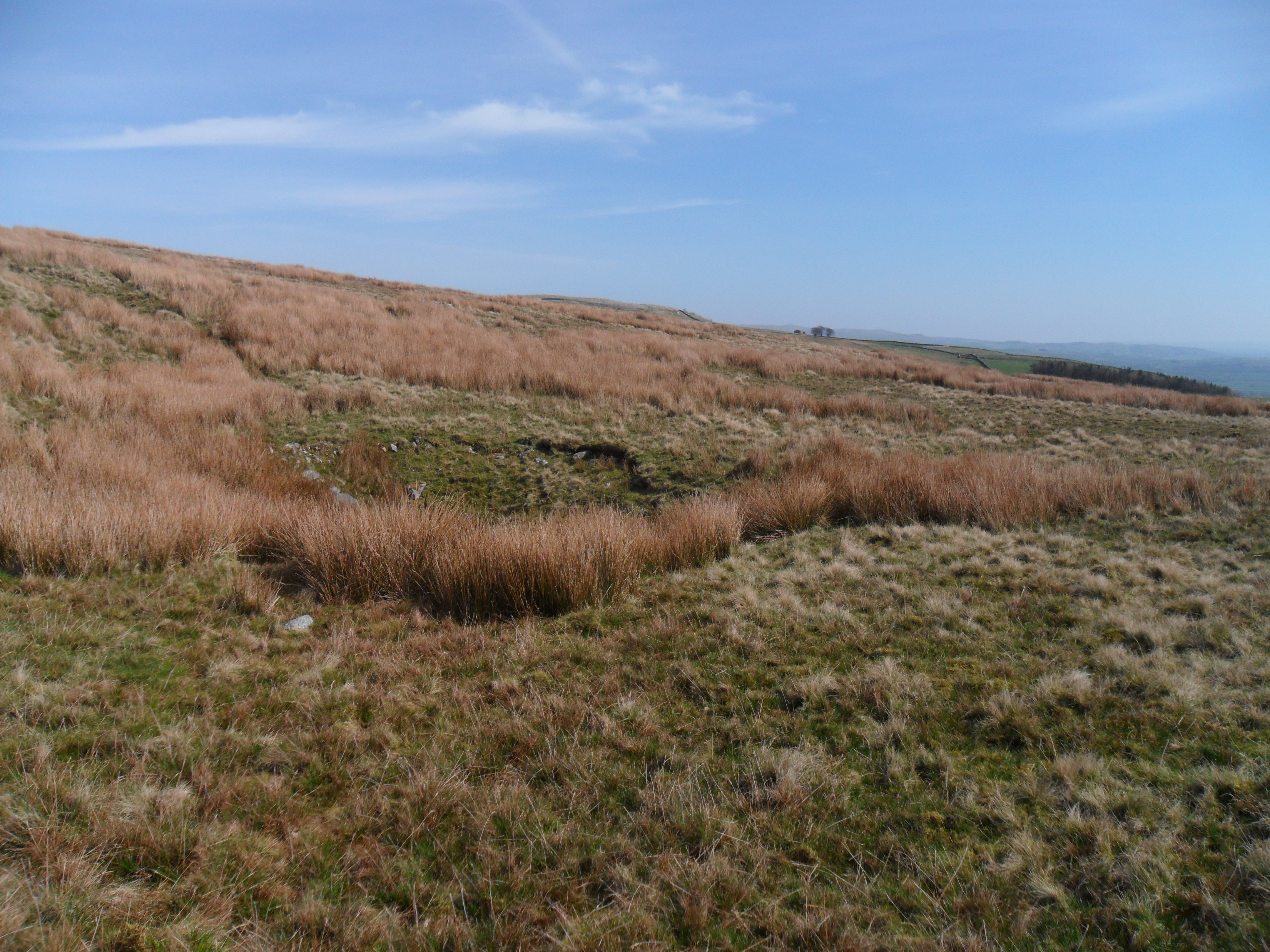
6. the channel bypasses another shakehole and then loses its definition in a scatter of shakeholes centred on SD73616 72146 (444m AOD) (image 82 looking south).

7. the channel then becomes more defined with a width of 600mm and depth of 300mm (image 83 looking south).

8. it continues as a well defined feature (images 84 looking north and 85 looking south).

9. after a pronounced break of slope at SD73563 71784 (428m  AOD) it is even more defined with a max width of 1m and depth of 600mm (image 86 looking south).

10. the channel bifurcates just before the shooting box, at SD73460 71593 (403m AOD) with one b ranch heading south and the other south-west (images 87 looking south-west and 88 looking south).

11. the south-west branch starts off with the same characteristics as the channel from here northwards but soon after passing below the cabin it is very different with long straight lengths and vertical, fresh-looking sides. The southern branch is as sinuous as the channel north from here.

12. the south branch develops a pronounced V-shaped profile with average depth of 500mm and average width of 600-700mm.

13. the southern branch  terminates c. 5m short of the pothole at SD7325 7122.

14. the south-western branch largely, but not completely, loses definition in a shallow limestone quarry centred on SD73167 71487 (images 89 looking south-west and 90 looking north-east).

15. this channel reaches the inbye headwall above Bleak bank at SD72589 71344 but there is no sign of a water smoot in the wall.

16. northern section ? length c 800m, height loss 54m = gradient 1:15                                                                                          south-western section ? c. 900m to the headwall, height loss 108m  = gradient 1:8                                                                  southern section ? c. 400m, height loss 75m = gradient 1:5

17. the First Edition OS 6-inch map, surveyed in 1846-47, marks Grey Wife Sike  only from Knoutberry Hole running south to a point level with the northern pothole (as in no. 1).
The Second Edition, surveyed in 1893, shows Grey Wife Sike running as far south as the southern pothole (as in no. 13) with the south-western branch only running a few metres past the shooting box at which point it terminates.
The Revised Edition of 1907 is as the 1893 edition.

18. Interpretations:
a. the Sike is natural from Knoutberry Hole to the northern pothole

b. from thence it is entirely manmade

c. beyond the (1893) terminus the south-western branch is a product of the twentieth century cut to tap into a series of ephemeral water flows from its uphill side

d. I can think of only one logical reason why the southern branch was cut to the southern pothole. I carefully looked beyond the pothole for any trace of where a channel might once have continued but  saw nothing. Indeed to the south of the pothole there is slightly rising ground, so it always ended at the pothole. 

e. the style of the southern branch is no different from that to the north: both were dug by hand.
f. the main channel, south from where it leaves the natural stream, was dug at some point between 1848 and 1892.

g. similarly, the shooting box was erected within the same time span.

h. from points f and g it can be concluded that the channel as far south as the shooting box was cut to supply water, when needed, to shooting parties. Grouse shooting on the Ingleborough Estate in the late nineteenth century was a major source of Estate income; indeed, the Farrers bought and developed it primarily as a shooting estate. Other shooting boxes on the Estate had readily accessible water supplies ? Moughton Whetstone Hole, The Allotment and Gayle Beck Lodge. This one, on Wetherpot Heath, did not.

i. I can offer no proof as to why the southern branch was cut except that a line of shooting butts closely parallels the channel so I would suggest that the southern channel was cut as a drainage feature to dry out the land along the line of butts. In those days the guns were mollycoddled much more than nowadays.

Compiled by Dr David Johnson
 

Pitlamp

Well-known member
Just for completeness, I recently walked up the ditch which comes down the N W flank of Cote Gill. It's fairly straight and obvious for some distance (heading just east of north - visible on Google Earth) but as you go over the immediate skyline (with Hurnell Ridge Sink away to your right) it seems to split into a few smaller and less directly aligned ditches. At least two of these may rejoin before it swings left to go directly up the hillside, to pass within a few tens of metres to the SW of Grey Wife Hole. Beyond here it becomes so indistinct I couldn't follow it with confidence. It may have captured water either from Grey Wife Sike itself or from the stream sinking into the Grey Wife Hole shakehole.
 

Pitlamp

Well-known member
Useful reference, just published:

Johnson D, 2021, Cuts, leats and races: water supply solutions in the Ingleborough area. North Craven Heritage Trust Journal 2021, pages 27 - 30.

This article also covers drainage channels further west across Chapel-le-Dale.

As an aside, pages 21 - 24 have a substantial obituary about Jack Myers and on pages 24 - 26 is a fascinating article by Bill Hinde about the construction (in 1952) of the Crosswall Shelter on the summit of Inglebrough, in which Gritstone Club members were particularly involved. (It saw substantial renovation work during the summer of 2020.)

The editor of the Journal has kindly donated a copy to the NPC Library, as Jack Myers was a member for many years.

The NCHT has a website where Journal articles are eventually uploaded: www.NorthCravenHeritage.org.uk  It'll be a while before the 2021 Journal articles finally appear there but if you have time on your hands whilst laid off from work in the current lockdown, have a look at the index of archived articles, some of which may be of interest to cavers.
 

Pitlamp

Well-known member
It may be that the following topic on here might relate to the above discussions, so here's the link. (Note particularly David Johnson's preliminary comments which I posted on his behalf on 16-01-24.)

 
Top