alastairgott
Well-known member
^thanks go to AR for number 9.


peterk said:There is a list of Derbyshire 6" sheets with the Roman numeral references at http://maps.nls.uk/os/6inch-england-and-wales/derbyshire.html They are hyperlinked to the online maps but it looks like the links are "down" (weekend maintenance?)AR said:The Roman numerals, as I understand it, relate to groupings of the old Ordnance survey maps - these groupings are of 16 maps for 25" and probably 4 for 6", group IX covers part of Chapel, Peak Forest, and Castleton. I'll have to have a proper look when get chance, also do a screengrab of the index map.
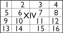
Within the 6" sheet the 25" sheets are numbered as:

Mark said:Index Box 7
https://www.dropbox.com/s/d36j032rhts6gjj/7-%20Box%20Index.xlsx?dl=0
Thanks again Alastair
mulucaver said:Nice to have the index in spreadsheet format. Any chance of getting the others the same.
mulucaver said:Nice to have the index in spreadsheet format. Any chance of getting the others the same.
Thanks MarkMark said:mulucaver said:Nice to have the index in spreadsheet format. Any chance of getting the others the same.
Box 9 Index (xlsx)
https://www.dropbox.com/s/p5njl2ysfk8ppwx/Box%209%20index.xlsx?dl=0
Box 8 Index (xlsx)
https://www.dropbox.com/s/3il78lgxr57daid/8-%20Box%20Index-2.xlsx?dl=0
There you go Dave
mulucaver said:Thanks Mark
For those who want to print out here is a cleaned up version with page numbers
https://www.dropbox.com/s/knhtb1dlwa8xwkc/Box%209.pdf?dl=0

")