

You are using an out of date browser. It may not display this or other websites correctly.
You should upgrade or use an alternative browser.
You should upgrade or use an alternative browser.
Stone shelter on Whernside
- Thread starter hannahb
- Start date
darkdescender
Member
Probably a bit too high up the hill to be the scource of the Whernside gold.")
JAA
Well-known member
To throw another suggestion into the mix….
Back when I was a gamekeeper on a grouse moor, in snowy weather at daybreak I’d follow fox prints for miles across the fells sometimes to locate the holes they used…. Usually the same fox will use the same hole repeatedly.
I’ve seen and indeed created artificial “earths” which looked very similar to this one so I had a good idea where foxes were likely to be headed for on snowy days….
But then it’s maybe a bit close to the path for that.
AKuhlmann
Member
It certainly should!AK - should your comment above refer to “flora”?
Mr Dinwiddy
Member
Not far from the grid reference are some very obvious and straight peat faces. These peat haggs on todays bogs are often evidence of former peat cutting. This aerial image is from close to the GR. So that might be some evidence that there was peat cutting here but not really any stronger evidence that the structure is a peat tile. But there was peat cutting all over the Dales uplands and take this with a pinch of salt because I am not an expert either !The peat tile theory would be reinforced if a nearby obviously manmade change in the fauna can be observed (like the square patches on Penyghent towards fountains fell) cased by the change in soil pH
Take with a pinch of salt because I'm not an expert")
Attachments
2xw
Well-known member
I am an expert (it's about the only thing) and I don't think those look like peat cuts - more like gully erosion - there's a lot of degraded bog up there (for a good example of old peat cuts have a look a few hundred metres south west of Dunnett Head). I'm unsure to the extent it would have been cut up there at all in the last 200 years as it would have been a pain in the arse to get down. Also not convinced you'd see changes in ph due to cutting, never observed that in my data! Is there really a history of peat tiles in England - most remote hand cuts I've seen just have the bricks piled on top to dry.
I'd probably be inclined to believe the archaeologist!
I'd probably be inclined to believe the archaeologist!
Last edited:
Pitlamp
Well-known member
Not far from the grid reference are some very obvious and straight peat faces. These peat haggs on todays bogs are often evidence of former peat cutting. This aerial image is from close to the GR. So that might be some evidence that there was peat cutting here but not really any stronger evidence that the structure is a peat tile. But there was peat cutting all over the Dales uplands and take this with a pinch of salt because I am not an expert either !
Thanks for this contribution. Those peat faces you drew attention to are about 150 m away from (and considerably higher than) the curious stone "entrance" which Hannahb described. If you look at the image below, you can see the minor path heading away rightwards from the ascending trade route. The entrance is just about where the first scree fan crosses this minor path. (It's right in the centre of this image.)
A few years ago something along these lines was built across the entrance to Haws Gill Cave (just up the dale from Haws Gill Wheel and down valley from Gatekirk Cave). As the "entrance" to this one was built from irreglar limestone lumps, rather than flat Yoredale sandstone slabs, an old concrete pipe about 250 mm O.D. was used to support the crude wall. This was almost certainly to do with animals using the cave entrance. I reckon JAA's suggestion has merit.
Pitlamp
Well-known member
By pure chance I was doing a job at Broadrake this afternoon, so I siezed the opportunity to nip back up Whernside to try to get a few more images. I'm not the world's best photographist but hopefully these pictures below will give an idea of what's inside. First one; the entrance. You'll not be able to see the graduations on the steel tape but when zoomed in it's clear that the entrance is 150 mm x 250 mm.
120224.JPG")
Pitlamp
Well-known member
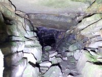
Here's the same view as the last one, lit differently (to allow a view further in). About 3 metres in there's a small earth mound across the passage floor, easily seen as the dark patch in this image. Beyond that the passage curves gently downwards, such that it is then hidden from view beyond about 5 metres in from the entrance.
On the hillside above the entrance there's signs of possible disturbed ground. About 5 minutes walk downhill there is what appears to be a bed of limestone. It's not exposed but there are what look like shakeholes. I'm wondering if the tunnel is a flue for a limekiln? The hillside is composed of deep scree, so easily dug into to construct a kiln with enough height difference to create a substantial updraught when operating?
Didn't notice any pixie footprints Roger.
120224.JPG")
On the hillside above the entrance there's signs of possible disturbed ground. About 5 minutes walk downhill there is what appears to be a bed of limestone. It's not exposed but there are what look like shakeholes. I'm wondering if the tunnel is a flue for a limekiln? The hillside is composed of deep scree, so easily dug into to construct a kiln with enough height difference to create a substantial updraught when operating?
Didn't notice any pixie footprints Roger.
Pitlamp
Well-known member
Thanks AR.
There is some blackening visible in this image starting two or three metres in. (Bear in mind this was taken with a wide angle lens.) I wondered if this is peat leaching but there isn't any peat on the slope above. So maybe it is soot? If the slabbed over tunnel is an inlet flue, I suppose there may not be any sooting closer to the entrance.
But I'm well into the realm of speculation now. We don't seem to have reached any consensus on this one, so I think it's probably time to consult the fount of all knowledge, David Johnson. Leave it with me and if I learn anything useful I'll post here.
Meanwhile (although I suspect this is off your patch AR) if you do happen to be nearby, maybe go for a look yourself?
Attachments
Pitlamp
Well-known member
Just been looking a bit more closely at the geology. That thick Yoredale limestone in which the Greensett Caves are formed (a bit further to the NE) must be very close by. Pretty sure this is the "Main Limestone" (which has the mightly Mossdale Caverns in it on the eastern side of the Dales caving area and a number of supersystems in the Northern Dales).
alanw
Well-known member
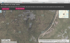
From the BGS Geology viewer. The green/blue is Yoredale Limestone, the red Yoredale Sandstone, the blue is the Main Limestone, the yellow is Stainmore Formation.
Sorry I can't find a way to provide a link zooming directly in to the Grid Ref, and my screenshot doesn't capture the mouse pointer, but I've added a red dot very close to where it was. The Grid Ref (SD735802) given in the first post seems to be spot on the boundary.

Sorry I can't find a way to provide a link zooming directly in to the Grid Ref, and my screenshot doesn't capture the mouse pointer, but I've added a red dot very close to where it was. The Grid Ref (SD735802) given in the first post seems to be spot on the boundary.
RobinGriffiths
Well-known member
Why would you have a kiln up there where there is so much more limestone further down - and easier fuel sources. Unless they were using thin beds of coal from the Main Limestone (which occur in some areas - although maybe not this) An intriguing mystery nevertheless.
Similar threads
