Looking for caves with LIDAR

Mr Dinwiddy

Member
I have been enjoying looking for caves using Digital Terrain Model LIDAR.

https://maps.nls.uk/geo/explore/side-by-side/#zoom=10&lat=54.22479&lon=-2.94377&layers=1&right=LIDAR_DTM_2m

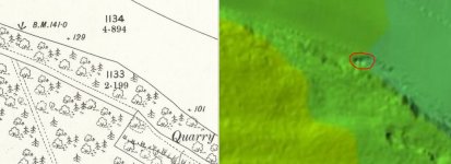
The side by side geo-referenced maps viewer allows you to put your mouse on a suspicious dark shadow on the LIDAR and the other "mouse" shows you where it is on the map. The big downside is that only the valley bottoms have been flown but its surprising the number of limestone areas that are covered. It is also maddening that some of the LIDAR stops just short of where I want to look.
I have been setting the left hand map series as OS 1:25,000 (old but lovely) and the right hand series as LIDAR DTM 1m.
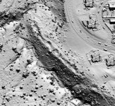
So far no new caves, but I explored (on my daily exercise) a small dry stream gorge I did not know existed and a series of tension release fissures on a scar edge. Both clearly stand out on the LIDAR which will also penetrate vegetation - great for wooded gorges and features otherwise hidden.
Hope you enjoy
DW
 

pwhole

Well-known member
I love how it neatly excludes all the bits I want to look at in the Peak District!

But it's a very handy resource to be sure, and will reduce the amount of time I pester my friend with the hi-res dataset - for the Sheffield area at least. I found several new holes in some woods last week and within six hours had a hi-res LIDAR image of them, thanks to him - very useful, though no clearer what they were for yet.
 

aardgoose

Member
The good thing is that the EA are now in the process of covering the whole of England, rather than those linked to the EA's hydrology interests. They do seem to be leaving the interesting areas to last.

There is an interesting public site with a high res scan of part of southern Scotland where they are getting public involvement in annotating interesting looking features for further investigation.  http://whiteadder.aocarchaeology.com/archaeology/
 

ChrisJC

Well-known member
aardgoose said:
The good thing is that the EA are now in the process of covering the whole of England ...

Is there a way of seeing progress?, I am very keen to see some places that are inconveniently omitted!

Chris.
 

mikem

Well-known member
Well, wookey hole is on there (& Alum)...

Aerial archaeology from 16 mins:
https://www.bbc.co.uk/iplayer/episode/p0109k4g/archaeology-a-secret-history-3-the-power-of-the-past
 

TheBitterEnd

Well-known member
Interesting resource, thanks for sharing. I went looking at some sites where I know there are small-ish caves to see how well they showed up

The first is a resurgence cave and is marked on all the OS maps, the resurgence is a good sized feature on the ground being a trench that is may be 3-4m deep before you enter the cave. It's fairly obvious on the Lidar

The second is a double shake hole that opens into a small cave, the shake hole is about 3m deep, I'm not sure I would have spotted this as a cave feature if i Hadn't known where to look.

BTW the map is the OS 25 inch 1892-1914
 

Attachments

  • FairesLidar.JPG
    FairesLidar.JPG
    68.6 KB · Views: 191
  • mam-lidar.JPG
    mam-lidar.JPG
    60.9 KB · Views: 175

Boy Engineer

Active member
pwhole said:
I found several new holes in some woods last week and within six hours had a hi-res LIDAR image of them, thanks to him - very useful, though no clearer what they were for yet.

If there are bears in the wood, I?d hazard a guess as to what they may have been burying.
 

pwhole

Well-known member
It's possible that two isolated and very large holes could be bomb craters - there were some dropped nearby, though probably dumping rather than targeted as it's in the middle of nowhere. The others are a line of at least six deep bowl-shaped depressions, average diameter 5m and 2-3m deep, all practically touching each other, on the top lip of a steep escarpment, which the BGS geology map shows to be the outcrop of a known sandstone unit. Mine shafts are unlikely as there's apparently no seams for another half a mile east. They could be pits digging out shattered sandstone for use as building or roofing material as the stone is very flaggy around there. Dunno really - still guessing. Below is a crop from the hi-res version my friend did me - the holes are clearly visible in an arc along the ridge. There seems to be another depression nearer the bottom of the slope so I'll have to go back and have a look before it gets too jungly.

I should point out that none of this is going to lead to any 'caves' in Sheffield ;)
 

Attachments

  • Crop.jpg
    Crop.jpg
    117.2 KB · Views: 164
At the Northern Explorers' Forum in 2019 (article in Descent by JNC), Noel Snape of ULSA gave a talk about using AI techniques to scan LIDAR images to detect shakeholes as opposed to other stuff.
 

Andy Farrant

Active member
More than likely old quarry workings for sandstone. Lidar is fantastic for defining areas of worked and made ground, and for identifying landslips.
 

Leclused

Active member
I think I've already posted this link : https://scavalon.blogspot.com/2016/01/virtueel-prospecteren-met-lidar_21.html

This article gives an overview of how in Belgium we can use lidar and other data to do virtual prospecting. In january I was working on an inventory of a specific area for Cwepss (organisation of the Wallone Region)  they gave me a couple of spots found by using lidar data to be prospected :)

BR


pwhole

Well-known member
Just for fun, here's a real-life photo of the central crater in that arc, showing just how difficult it is to capture anything useful in these conditions - it'll be even worse in a month - definitely a winter pastime! It's about 5m X 3m X 2m deep, and the steep slope down is just beyond the hole. If I didn't have such a nose for this stuff now, this would be unknown. And so it's a very good case for scrutinising LIDAR beforehand to look for stuff like this, as it saves so much time - in this case I was able to use it as confirmation, which was nice.
 

Attachments

  • _IGP1887_sm.jpg
    _IGP1887_sm.jpg
    312.8 KB · Views: 169

Graigwen

Active member
Andy Farrant said:
More than likely old quarry workings for sandstone. Lidar is fantastic for defining areas of worked and made ground, and for identifying landslips.

The I'r de o Draenen project has made extensive use of LIDAR scans and we have found it very useful.

As Andy says, it is good for detecting worked or otherwise disturbed ground. Obviously not everything you notice on a LIDAR scan will turn out to be interesting when you inspect it up close. More than once I have skived off from a dig for a couple of hours to "..check out something on the LIDAR scan" and come back to admit just finding another small long abandoned quarry.

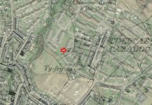
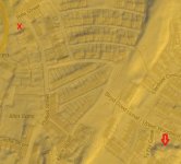
We find more leads from LIDAR than we can follow up, so in keeping with our collegiate  spirit here is (as far as I know) a virgin site if anyone wants to check it out. It shows that LIDAR can be of use in urban as well as rural environments. It is in Blaenavon town, not exactly above Rifleman's Chamber but not far off.

Grid ref SO 25550 09181

Location Just off Upper Woodland St., side of Ty Fry Close.


In 1980 this was interpreted as water sinking through younger rocks and entering solution passages in the Llanelly Formation before proceeding into larger voids in the Gilwern Oolite. A representative of my old employers who was doing drilling down nearer the river said "The clay bands within the Llanelly Formation behave as aquicludes and extensive cave development in the Llanelly Formation is consequently unusual but more common in the thick bedded, well-jointed limestone in S2 above and Gilwern Oolite below."

Attached (hopefully) are a superposition of the LIDAR scan on a modern map and a superposition on the modern landscape of the 1902 6" O.S. map showing the site as a well.
(Riflemans' Arms has been marked with a red cross)

So there you are, on a plate, maybe the 22nd entrance to Ogof Draenen.

.
 

Attachments

  • Ty Fry 2.jpg
    Ty Fry 2.jpg
    147 KB · Views: 172
  • Ty Fry LIDAR 2.jpg
    Ty Fry LIDAR 2.jpg
    73.4 KB · Views: 736

Graigwen

Active member
Yesterday on my way for a lunchtime pint in the Castle, Blaenavon I noticed that the vegetation surrounding the Ty Fry doline had been cut back, allowing a much better view of this landform.

It is about 75 feet across and 20 feet deep. It is not exactly photogenic but here are a couple of pictures. One shows a flat area in its bottom apparently covered in fine sediment. A resident who lives alongside it said that he had never known it to be filled to the brim with water. I imagine that any water that intermittently sinks here soon finds its way into Ogof Draenen.


Attachments

  • Ty Fry 1.jpg
    Ty Fry 1.jpg
    887.5 KB · Views: 152
  • Ty Fry 3.jpg
    Ty Fry 3.jpg
    558.4 KB · Views: 165

JamesM

New member
With the EA they also do down to 25cm spatial resolution which is really interesting to look at, albeit the coverage is mostly where there are capital projects or higher flood risk. All the datasets have an vertical accuracy of 15cm
 
Top