

You are using an out of date browser. It may not display this or other websites correctly.
You should upgrade or use an alternative browser.
You should upgrade or use an alternative browser.
Is it safe to go caving yet? Modelling cave flood events in Yorkshishire
- Thread starter Hall2501
- Start date
TheBitterEnd
Well-known member
It seemed to me that the rainfall radar would be useful for this kind of thing because it gives intensity and location so I asked the met office if they made historic rainfall radar data available but they don't and apparently they don't even record it. I did wonder if it would be possible to screen-scrape the rainfall radar map but never got around to trying.
PeteHall
Moderator
mikem said:Although helpful, levels will invariably have changed by the time you get there - you also want to know whether it's rising or dropping!
Depends on the cave. I'm particularly interested in the local water table in the bottom of Charterhouse, which rises and falls very slowly, so you can never predict if the lower reaches will be accessible, regardless of recent weather...
I've been planning to chuck a couple of data loggers down there to try to correlate it with rainfall data, but not got around to it yet...
While the science interests me, I'd actually be happier if I knew how far I was likely to get before setting off so I don't waste effort carrying kit that won't get used...
Chocolate fireguard
Active member
A couple of years ago there was a thread where using an underground stream to produce electricity via a water wheel and generator was mentioned (I think it involved recharging a battery that would be used to power a ventilation fan).PeteHall said:Would it be incredibly far-fetched to have a monitoring station underground, (perhaps charged by a water driven turbine?), with a cave-link type communication to a weather station on the surface?
You could potentially see live(ish) data for the cave online before planning your trip
Out of interest I bought a cheap motor/generator from eBay and connected the output via a switch to a 12V 5W car bulb. With a 15cm spindle through a hole in the end of the shaft it was possible to turn the thing very easily with the switch open, but as soon as the bulb was switched across the output it became much more difficult.
Nobody ever gets close to lighting the bulb at normal brightness. With a couple of meters in the circuit the maximum output I can manage is less than 2W, and even assuming an efficiency of perhaps 20% (like I said, it was cheap) I guestimated from the feel of it that a water wheel to drive a more efficient one wouldn?t be a practical proposition using the small and intermittent streams nearby.
Google found several articles on Cave Link. The only technical stuff was in German, which I don?t read, but there was a picture of some hefty looking batteries in the bottom of the box. There were some things that might have been power consumptions but I couldn?t really tell.
So the turbine idea might be a goer, but it depends heavily on the power needed and what streams are available nearby.
I have my doubts ? conservation of energy has bug***ed up a lot of good ideas over the centuries!
Bob Mehew
Well-known member
https://www.cave-science.org.uk/ contains a mine of data on cave climate. I am unsure if Tony Goodsell's water depth recorder data is included but is probably available. You might like also to think about drip rates verses rainfall which I guess is the primary link for normal conditions. If you are only interested in surges, then it is back to rain, state of land and drainage basins.
Given normal variations in atmospheric pressure can equate to 0.3m of water, it is difficult to make something waterproof. Tony's detector uses O rings. So you may wish to install a bag of silica gel to absorb any moisture which gets inside plus apply a conformal coat to your electronics to minimise the impact of moisture. My kit lasted two weeks before what I presume was moisture killed it. So plan on returning frequently to check thingsblhall195 said:It uses a waterproof ultra sonic distance measuring sensor ... as the prototype isn't completely waterproof (IP67).
aricooperdavis
Moderator
TheBitterEnd said:I asked the met office if they made historic rainfall radar data available but they don't and apparently they don't even record it. I did wonder if it would be possible to screen-scrape the rainfall radar map but never got around to trying.
You can actually get the layers through the DataPoint API I think, which is very convenient for saving them whilst you're running the experiment.
TheBitterEnd
Well-known member
Looks like things have moved on since I asked them.
Tim Pickering - showcaves being normally resurgences, their water is often collected from a very wide area, where differing rainfall over the catchment may result in variations in observed levels & timings. Some of that water will come directly through large conduits, so providing rapid & often muddy influxes, others through tiny passages, some may cause flooded chambers to overspill, thus forcing cleaner water through the system & sometimes that overflow may be overwhelmed (or become blocked) & rise to another passage that takes it off in a different direction (plus all the variables in ground / saturation conditions mentioned already)...
I think the API includes rainfall records from weather stations, rather than radar data, which could be interpolated for sites in-between.TheBitterEnd said:Looks like things have moved on since I asked them.
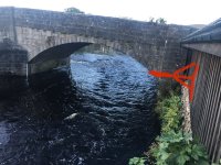
blhall195 said:Ideally I'd put it on a bridge somewhere that already has a monitoring sensor to check it's working properly before leaving it in a cave.
I'd just need to work out how to secure it to the bridge in a way that's discreate enough for people not to care it's there, maybe alongside the existing river level monitoring equipment.
Not sure if any use (the tech side of things is out of my league).
Opposite the webcam quoted above, we have a building adjoining the river where a simple timber bracket could be fitted, projecting over the river at a height to suit. The area is secluded and not easily accessible.
Making and fixing a timber bracket is in my skill set and I am sure the CPC would be supportive.
Ian
Attachments
aricooperdavis
Moderator
mikem said:I think the API includes rainfall records from weather stations, rather than radar data, which could be interpolated for sites in-between.
I could be wrong as I haven't actually tried the radar service yet, but there is documentation for how to fetch rainfall radar tiles using datapoint on the Met Office website, so unless this is no longer or not yet supported it should be doable?
Tim Pickering
Active member
mikem said:Tim Pickering - showcaves being normally resurgences, their water is often collected from a very wide area, where differing rainfall over the catchment may result in variations in observed levels & timings. Some of that water will come directly through large conduits, so providing rapid & often muddy influxes, others through tiny passages, some may cause flooded chambers to overspill, thus forcing cleaner water through the system & sometimes that overflow may be overwhelmed (or become blocked) & rise to another passage that takes it off in a different direction (plus all the variables in ground / saturation conditions mentioned already)...
I've noticed times when the inlets are responsive but the streamway level remains relatively unchanged or the streamway at the far end of the show cave may be higher than normal but it hasn't affected the level nearest the entrance. I will at some point have a wander around and note down all the sinks and resurgences in the vicinity, and hopefully get down some of the pots. Absolutely fascinating stuff! I've given up using the river stage as an indication of whether we'll be running tours.
River level is only a good indicator for water flowing through vadose (open) passage, whilst most resurgences are phreatic.
Yes it is available for next 36 hours, but TheBitterEnd was asking about historical data to compare to past events.aricooperdavis said:I could be wrong as I haven't actually tried the radar service yet, but there is documentation for how to fetch rainfall radar tiles using datapoint on the Met Office website, so unless this is no longer or not yet supported it should be doable?
TheBitterEnd
Well-known member
aricooperdavis said:mikem said:I think the API includes rainfall records from weather stations, rather than radar data, which could be interpolated for sites in-between.
I could be wrong as I haven't actually tried the radar service yet, but there is documentation for how to fetch rainfall radar tiles using datapoint on the Met Office website, so unless this is no longer or not yet supported it should be doable?
I had a quick play with the radar API last night and it is possible to get tiles of radar data - this page gives the basics > https://www.metoffice.gov.uk/services/data/datapoint/inspire-layers-detailed-documentation
The met-office don't seem to give much info about zoom, style, and how to relate a tile to an actual location so it's a case of getting into the OGC WMTS 1.0.0 spec which didn't make things immediately obvious. If I'm bored at some point I might dig a bit deeper.
BTW, I don't see interpolating between gauge sites as being of much use for heavy localised showers, that's the strength of the radar data for me.
Hall2501
Member
Finished the prototype of the cave river level logging device.
Currently it's a stand alone unit that can tell the date/time, the distance of the nearest object (river) using an ultrasonic distance sensor, then log to a micro SD card and display on a small LED screen. Once i've optimised the power settings it should be able to log for months at a time.

The display shows the date/time + how far away the nearest object is.

It also shows whether the SD card has initalised properly and if there are any data logging errors (this can be unplugged once it's set up and working to save power).


The log file is simply a CSV file with a time stamp and river height.

There's still alot to do in terms of optimising the design for minimal power consumption and finding a way to make it cave proof.
I currently have an IP67 rated junction box that I'll put a few packets of silica gel in and have the sensor extending out via a cable.
I'm planning on reducing the power consumption by:
- removing the LEDs
- making the sample frequency dependent on the hight of the cave water levels (e.g 1 data log every 15 min under normal conditions, every 5 min under flood conditions)
- setting the device to a sleep state when it's not doing anything
I'm thinking to use the kingsdale master cave streamway near the pitch as you go in from valley entrance as a pilot study, just because I enjoy doing the pull-throughs anyway and the water levels probably respond predictably to rain fall.
Just need to find some way of fixing the logger in the cave that won't piss people off.
The sensor I have is pretty cheap (?10) and the range/resolution isn't as good as some of the professional grade sensors on the market that cost over ?100, I might see if the BCRA will buy me one for christmas :ang:
Currently it's a stand alone unit that can tell the date/time, the distance of the nearest object (river) using an ultrasonic distance sensor, then log to a micro SD card and display on a small LED screen. Once i've optimised the power settings it should be able to log for months at a time.
The display shows the date/time + how far away the nearest object is.
It also shows whether the SD card has initalised properly and if there are any data logging errors (this can be unplugged once it's set up and working to save power).
The log file is simply a CSV file with a time stamp and river height.
There's still alot to do in terms of optimising the design for minimal power consumption and finding a way to make it cave proof.
I currently have an IP67 rated junction box that I'll put a few packets of silica gel in and have the sensor extending out via a cable.
I'm planning on reducing the power consumption by:
- removing the LEDs
- making the sample frequency dependent on the hight of the cave water levels (e.g 1 data log every 15 min under normal conditions, every 5 min under flood conditions)
- setting the device to a sleep state when it's not doing anything
I'm thinking to use the kingsdale master cave streamway near the pitch as you go in from valley entrance as a pilot study, just because I enjoy doing the pull-throughs anyway and the water levels probably respond predictably to rain fall.
Just need to find some way of fixing the logger in the cave that won't piss people off.
The sensor I have is pretty cheap (?10) and the range/resolution isn't as good as some of the professional grade sensors on the market that cost over ?100, I might see if the BCRA will buy me one for christmas :ang:
Chocolate fireguard
Active member
You don't say what the range is, but the 81cm reading implies that the resolution is more than adequate, bearing in mind the changes produced by flooding and the likely second by second fluctuations in the bit of river it is looking at.
Re. making it cave proof, decades ago I built some photoflash slave units, using a circuit from Descent, and after many failures I found the only way to keep the water off the electronics was to pot everything apart from the batteries.
It's pretty final, but have you considered it?
Re. making it cave proof, decades ago I built some photoflash slave units, using a circuit from Descent, and after many failures I found the only way to keep the water off the electronics was to pot everything apart from the batteries.
It's pretty final, but have you considered it?
Hall2501
Member
From what people are saying it seems flood events can be quite sudden and short lived. I could alter the programming so that the sample frequency increase changes on a sliding scale directly proportional to the river level or increases the same rate as the rate of change of river level.
The range of the ?10 sensor is about 5m with a cm resolution. The ?120 sensor I want to buy has a range of 10m and mm resolution - but more importantly compensates for changes in humidity and temperature.
In terms of potting I hadn't considered this it's modular so could be a good idea for conserving the more expensive bits of the device like the sensor chip and then I just change the cheap components if it's compromised by water but my main priority would be finding a way to make it as water proof as possible inside the box, lots of silica gel around the seal and either washers or a cable glad for the sensor.
Sent from my AC2003 using Tapatalk
Hi
I installed a very similar water height module in Pooles Cavern, worked fine for a couple of months over the lock-down, but eventually died due to water ingress, as most things do!
Bit more work to be done in 'potting' the sonic head.
The accuracy of the sonic unit is very dependent on the temperature, when using it outside an error of +/- 1cm (over 2m) can be seen during a warm day, luckily for cave use this is fine.
Details of the unit and other stuff is on my website. goodsellsystems.ltd
TheBitterEnd
Well-known member
Radiospares and the like sell the sealed automotive ultrasonic transducers and they seem to survive the wet for years, just a thought.
Similar threads
- Replies
- 5
- Views
- 861
