• Canal Cave - Nidderdale

    Some interesting exploration techniques.

    'The next thing was to purchase a generator and pump. The plan being to test pumping out the flooded bedding in Lofthouse pot and fill HUTWP. The latter in a vain hope of creating water pressure to open up the choked bedding'.

    Click here for some excellent before and after shots

Mysterious Cave/Tunnel Salcombe Area

tombarnes05

New member
Evening all,

This is my first post on this forum so apologies if I'm breaking any rules. I've read through and don't think I am.

Whilst out on the boat yesterday my Dad and I spotted a small opening in the cliff above a small isolated and tidal beach near Soar Mill Cove. The opening was highlighted by a stream of what we think is rust coming out of the cave and down the cliff.

We decided to beach the boat in this small cove to go and investigate. Upon closer inspection and a little wonder inside, we decided the cave was more of a man made tunnel.. We didn't go any deeper as we only had flipflops and a phone torch and thought we could go home and find lots of details and photos online..

After an hour of research we have found absolutely nothing.. does anyone recognise this tunnel/cave or know anything?
343a747082e99755ae84bfa4f46bcaad.jpg


Sent from my GM1913 using Tapatalk
 

alastairgott

Well-known member
I've had a quick look on the Adit now maps, and cannot find anything around that area. From walks round there about 20years ago there were WW2 fortifications on the headland. So maybe it is something to do with that?

Only I can't find them on Google satellite I just know there are fortifications on that stretch of cliffs near overbecks.
 

alastairgott

Well-known member
Stumbled upon a reference to a "bull-hole" on the devon live website, but it's full of flashing adverts and general rubbish. probably a better referance for it is

https://books.google.co.uk/books?id=tqgwAAAAYAAJ&pg=PA103&lpg=PA103&dq=%22Bull-hole%22+in+Salcombe&source=bl&ots=5_1tnVPJQ7&sig=ACfU3U1pLvaao8OUnduVI7oxt40bNzZkNA&hl=en&sa=X&ved=2ahUKEwiI3POpruTqAhXPTsAKHZ8tA7AQ6AEwCXoECAkQAQ

in Kingsbridge and Salcombe, with Intermediate Estuary, Historically and Topographically Depicted
by Abraham Hawkins, ?A. J. Hawkins - 1819 - ?Kingsbridge (Devon, England)
 

tombarnes05

New member
Hi all,

Thanks for the response and interest.

I believe bulls hole is in a cove at the mouth of the estuary.

For some reason I'm limited on the number of photos I can add so I've created a Google photos Album for you to access. There is also a screen shot of the grid reference on maps and you can see the rust stream coming out the cave.

https://photos.app.goo.gl/5Ps3ZX2xnAsDgueA6


Sent from my GM1913 using Tapatalk


Wayland Smith

Active member
Don't know anything about the area
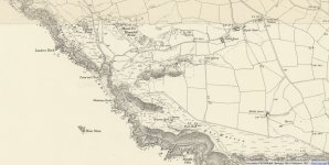
but interestingly on older O/S maps it is called Sewer.
https://maps.nls.uk/geo/explore/#zoom=16&lat=50.22376&lon=-3.82378&layers=171&b=1
 

Attachments

  • Screenshot_80.jpg
    Screenshot_80.jpg
    679.5 KB · Views: 337

tombarnes05

New member
Very interesting thank you. I believe sewer mill is not known as soar mill cove and it's further west up the coast.

That map does show a lot though including these references in the same cove.
0de50eeecb22b20bd33c094fe8027695.jpg


Sent from my GM1913 using Tapatalk


mikem

Well-known member
It appears that Hugh's hole is an enclosed beach & ferny holes / Vincent pits are natural features:
https://www.gutenberg.org/files/58456/58456-h/58456-h.htm
 

mikem

Well-known member
This report mentions an unsuccessful copper mine at Ralph's hole being worked by John Easton of Dodbrook in 1770 (at SX67943875 - which is close enough to make no difference as they didn't look for it & it was iron pyrites):
https://docs.wixstatic.com/ugd/9d246c_35a9f9cb9d4e4f679f617941b65231f4.pdf

Reference comes from here (p.111, same book Alastair linked):
https://books.google.co.uk/books/about/Kingsbridge_and_Salcombe_with_the_Interm.html?id=tqgwAAAAYAAJ&redir_esc=y

Also mentioned in this, along with others nearer Bolt Tail & a bit further north at Thurlstone:
https://www.thurlestoneparish.co.uk/uploads/4/8/9/6/48967079/village_voice_2004_number_129.pdf
 

tombarnes05

New member
We've also just found this and it looks like this is the failed copper mine. I'm surprised nobody else has looked or found it before.

Thanks for your help all.

Sent from my GM1913 using Tapatalk


mikem

Well-known member
The parish news names someone who had explored it, & you're right, it is rust washing out, from the iron pyrites.
 

AR

Well-known member
The profile of the adit is typical of an 18th century mine level, if you ask on Aditnow you probably will find that there are people there who know more about it.

Edit - just noticed that you have posted there.
 

tdobson

Member
I believe it might be called Easton's Mine - as that's a known adit in Hugh's hole.

I'm afraid I don't know more.

Give it a few years though and I'll definitely have a go at finding time to poke my head in. I don't expect much, but you never know til you know.
 

tdobson

Member
I found out a bit more in an old book, that show's it's definitely the place.

Screenshot from 2023-09-28 00-11-17.png

About twenty yards from Easton's mine is a most admirable and abundant chalybeate spring, very pure, and grateful to the taste. In combination with the advantages of marine air and water, sea bathing, the fisheries, & this spring I consider as inestimable, and that it will one day be the means of drawing to the vicinity a great resort of wealthy invalids and others, and make the neighbourhood of Hope and Salcombe rich and prosperous.

Screenshot from 2023-09-28 00-10-07.png


This is clearly the outflow that's visible... No queues of invalids paying to bathe in it though....

Easton's Mine is also referenced briefly here.

I think it's a short trial, because it was pronounced "mundick"

In addition, I believe (based on the village voice attached) and this book, there's a dodgy iron mine somewhere on greystone ledges/head nearby.

I'm not local, but hoping to visit this at some point. I think it's possible the South Devon climbing guide suggests an 'easy' scrambling route into Ralph's Hole, but I'm not sure.
 

Attachments

  • village_voice_2004_number_129.pdf
    2.7 MB · Views: 143
Top