Ed W
Member
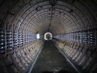
Great introduction to caving on Portland Tim.
Having been to the bitter end of Sandy Hole on a number of occasions I can add a little more detail.
The cave has been surveyed, and the survey inconsistencies were sorted and the end radio located. The survey was completed before the end of the Century but has to my knowledge has never been published. I understand that the far reaches of the cave have turned distinctly left / east away from the cliffs on the west coast and towards the dry valley leading from Sweethill towards Culverwell (the source of the only stream on the island)
The cave is more complex than shown, with several oxbows and splits into two branches at the end (probably the start of another oxbow). The passage is quite large in places, annoyingly no higher but several metres wide in some places. There are also several tiny "avens" (too small to get into) that penetrate through the chert band that forms the passage roof (and supplies the razor sharp splinters that are impregnated into the mud). There are even some very nice formations in out of the way places if you know where to look.
It takes about 4 hours to reach the end, and my longest trip was over 17 hours. This included surveying and exploration (discovery of Apology Passage - we were sorry we found it). There are still "open" leads towards the southern extremity and the prospects for finding even more sharp, muddy crawling are excellent.
")