Warning - major collapse at Odin Mine

pwhole

Well-known member
Roger

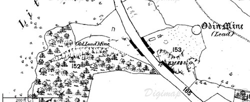
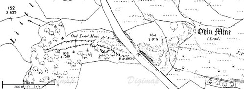
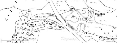
Remember that when Royse sank the shaft, the entire gorge floor would be about 20 feet lower than present. Also if you're referring to the current entrance as the top slot in the rock, then the cartgate may well be 80 feet below that, but that's a long way up from ground level.

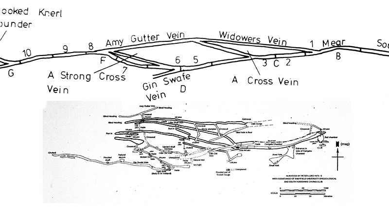
But I am baffled by both Chatburn's and Royse's descriptions (I have his old book), as neither really tally with the present workings. If they dropped into the parallel passage that leads to the Bell Chamber, then I don't know where, as that has a solid roof, although I've never explored far west from the crosscut. They must have come in somewhere behind the current blockage, but Royse then describes crosscuts in the arching like boxes in a theatre - there's only one crosscut in the accessible cartgate. I still think the Widowers Vein holds some of the clues to all of this - it's totally unsurveyed, and the (now blocked) lower level entrance was right at Royse's shaft point - maybe it wasn't blocked in 1927?

As for how to support the backfilled entrance passage, I really have no idea at present - I'm no engineer, but it's a tricky job, as it's mixed shale and loose rock. Tracking the extent of the crossover of that vein with the stempled passage beneath is also tricky as it's technically a crosscut, which means it should be mostly in solid rock, but no-one has much idea of what's stacked above those stemples - their presence alone suggests something. But supporting from underneath seems fraught with risk, as shifting the weight distribution could add more instability, not less. If any mining engineers are reading, I'd love to hear a more expert opinion!

Phil.
 

pwhole

Well-known member
Regarding the collapses, here's my options:

1. The infilling by the spar-men was done really badly, with some huge boulders dropped in the bottom with voids between (but above the mine workings), which are now settling dramatically.

2. The cartgate roof was stempled or arched much further back toward the road, and that has collapsed, although the line of the cartgate may be further to the south in reality - ie under Odin Cave.

3. My preferred option - the workings in the roof of the Bell Chamber are running in. There's very little contemporary info on this stuff. Here's my theory:

Way back, around 1670, there were a few meers being worked east of the road, but only two west - starting from the drill-mark next to Odin Cave, two meers takes you to the very bottom of the steep slope in the gorge. These meers were overseen by Robert Hallom, and within these two meers was a working called 'Deepe Shafte', or 'Hallom's Shaft'. Knowlegates Sough wasn't yet cut, so there were no low-level workings to consider yet.

On the old 1750's plans, there's also an 'old pipe' in the first two meers called 'Toume Hole', or 'Joume Hole'. This could be referring to the natural opening high in the south wall of the cartgate with a natural spring, now called 'Jose Hole', but I think it refers to the same Hallom's Shaft, which is a worked-out pipe, and doesn't appear to be part of the main Odin Old Vein system. The lowest workings in the Bell Chamber reach the later altitude of Knowlegates Sough, and probably connected at the back of the nasty rift you reach through the dodgy hole at the back of the main chamber.

However, once you drop into the main chamber, after the first pitch, you can then climb back up the western wall, and reach a ledge, which connects to some further, and much tighter pipe workings trending back up, and to the north; ie out under the grassy area. These workings were extensive, and a bit scary, as much of the roof is a crumbly shaley/boulder bed mix, but they went further than we expected, and we explored part of them. There was a shaft heading back down in the furthest chamber, and lots of u-bend crawls to negotiate. I don't have any photos of those workings, but the climb up, and hole in the back of the chamber leading downwards, are in and around these pics:

http://www.mine-explorer.co.uk/view_picture.asp?id=29458

As far as I can tell, none of this is represented on the survey, and could be some of the earliest workings in Odin, with huge archeological value. But they could also be the source of the collapses above, as they seem the nearest, and most northerly. If anyone else has ever been  up there, it would be good to hear from them. Dunno if Cave Troll or Brendan have?

This color version of the collapse photo may be better:

http://www.mine-explorer.co.uk/view_picture.asp?id=29516
 
The way on West would be to follow the Cartgate back towards Chippendale Rift and then where it would continue dig through that collapse.....however.....where I have been on 'Amy Gutter' vein is approximately (I think) the other side of that collapse. The level there had rails and sleepers in the floor and so is probably the Cartgate. It ended in almost immediate collapse East and went for quite a way west before it was run in. This point is where Rich Bartrop and Bob Grimes dug for a while back in the late eighties befre giving it up as suicidal....
Cave Troll has been to the bit I'm on about - with Tim Rivett and others. They found some interesting artefacts.....

D.
 

Mrs Trellis

Well-known member
A pre WWI OS map would be useful. The road etc. may have changed but Odin Cave and the shaft on the eastern side of the road are unchanged.
 

Roger W

Well-known member
Well done, Sam!

The road seems to have been there (with the OS benchmark!) since 1880...

Can't make out the cave, though    :(

Is that the course of the cartgate that can be seen on the 1890's map?
 

Roger W

Well-known member
Phil,

Comparing your colour photo of the surface collapse with the one on Winstercavers, it looks to be the same hole, but much bigger in the Winstercavers photo.

What's the latest there?  Is it now even bigger, or have the NT wallahs filled it in?

Ought to pootle down and take a look, but I'm busy re-laying my drive at the moment (where's the "aching back" smiley?)

Roger
 

pwhole

Well-known member
I haven't been up there since just after the closure notice was put out, and the collapse didn't seem any bigger then. I've been busy on other projects all summer to try and stop thinking about Odin as much, but it's clearly not working - I'm itching to get stuck in.

Dan - you know where the cartgate above Chippendale connects to the stempled passage at the t-junction, and then continues for about 30m to the man-made arch? After that, the roof appears to dip down, and the stemples taper down in length, as the 'floor' also rises. I'm assuming that's the collapse you refer to?
But what do you think is going on there? It does seem to be the logical continuation of the cartgate passage, but unless the original floor dipped away, I can't work out how it 'ran in' at this point, if indeed it did. The roof situation says maybe not. It may have been filled in by hand from this end? These two show it:

http://www.mine-explorer.co.uk/view_picture.asp?id=29437
http://www.mine-explorer.co.uk/view_picture.asp?id=29438

Shortly after the most westerly surveyed Amy Gutter workings, and roughly below Tinker's Shaft, there should be another rither point where the cartgate vein rejoins Amy Gutter, according to the old plans - I'm wondering if the 'suicidal dig' was around this point?
 
Phil - that is exactly where I mean, just beyond that lovely stone pillar. Digging there would I think take you to where I've been further in. The suicidal dig is further along from there.

D.
 

pwhole

Well-known member
Dan - now I'm not so sure - they don't look that close together on the survey. Your dig should be way off in the top-left corner. The original description by Peter Lord also mentioned that another portion of the cartgate was discovered, via the big west pitch, then traversing back along Odin Old Vein from a crosscut - however, I'm starting to wonder if there's more than one 'cartgate', or that it's not a contiguous passage for its entire length, as he refers to it on the survery as Knowlegates Level.

Anyway, check this out - this is a comparison image, scaled as best I can, matching the original 1750's plan with the current accessible workings - the basic outline is quite obvious, as is the rither point I mentioned earlier, at Point 'F' - the current survey seems to all show 'blocked' just before the veins ought to meet up. Incidentally, the unexplored 'Knowlegates Level' is visible in dotted lines continuing west from the current cartgate end.

Odin_survey_plan_comparison.gif


The original plan was only drawn at cartgate level, although Gin Swafe and Slicken Drift veins are actually much lower in the mine - at the Trickett Sough altitude, and where TW was, as far as I can tell. So it's only an approximation - but, most excitingly - Amy Gutter Vein and Widowers Vein appear to meet 'indoors'. More to chew on, anyway...
 

nickwilliams

Well-known member
Have you checked to see if the Peter Crabtree logbooks (recently donated to the National Caving Library) contain anything useful on this site?

Nick.
 

pwhole

Well-known member
Hi Nick - no, I haven't, though mainly as I was unaware of them! I'm admittedly not that au fait with past caving exploits and histories, being a relative newcomer to the discipline. How would I get access?

I will have a look through the TSG library asap, as there must be some old trips logged in past journals. Also the original Peter Lord survey was done with assistance of SUSS, and I'm certain there must be at least a higher-res version of that in their archives somewhere...

There's some huge gaps between the drawing of the old plans (1750-1820), the closure of the mine (1869), and the latest survey (1975) - it doesn't appear that Royse and co drew any internal sketches of their efforts, which is a real shame. If Rother Valley Caving Club were in there digging in the late early 60's, it would be good to know what they did also - how or what they ended up as though, I have no idea.
 

SamT

Moderator
I was chatting to Mark Noble last night - who said he was in there a lot back in the day, '70s I think. 

He mentioned Lords survey and I was reminded of Dave Elliots little guide which I'll scan and post up.  I had it as a kid (I used to play up around odin as a youth) and remember that is made it out to be the living end,  Mark seconded that last night.

I'll get scanning. 
 

Mark

Well-known member
Amazing place Odin, when we were surveying it with Pete Lord and Co in 1973/74? I remember a Cartgate at a lower level (possibly part way down a pitch) but the floor was deads which kept collapsing when you trod on them, we could see the passage going off into the distance but there was no way of safely getting along it, so left it.

Might be a different story now with battery drills etc (Can I remember where it is, can I bollocks)

Also going down the 125ft pitch and then down 3 or 4 other pitches we got to flowing water with a bit of a duck and bits of natural. but while we were in the bottom we could hear stuff collapsing above us somewhere, but no obvious signs on the way out?
 

Roger W

Well-known member
Thanks Sam  (y)

Gosh, he makes it sound like a really nice place to have a pootle around in. 

And Mark's comments about how he "could hear stuff collapsing above us somewhere" are really encouraging too!

Seriously, do you guys think there is a real possibility of stabilising the place?
 

droid

Active member
Reading Jim Rieuwerts' book, Oden has been worked underground for at least 260 years. possibly more. The easterly end (going west from the Gorge) is the oldest so it's hardly surprising that it's a bit unstable. It was abandoned for about 60 years from the late 18th century which doubtless didn't help....
 

pwhole

Well-known member
Sam

Thanks for that - very handy indeed! Good to see some actual exploring reported, as opposed to just rumour. Interesting comments on the lower levels accessed via the hole at the base of Chippendale - the unstable wet pitch sounds like the one we descended last year, but it wasn't that bad as far as I remember. The crosscut at the bottom of that also seemed OK too, and I'm certain we found an old hanger at the point where that level has a vertical intersection, up and down. It was definitely blocked at the bottom of that, and the level that continues west beyond the hole.

Phil.
 

bograt

Active member
This place was the scene of one of my first rescue callouts, also tried to kill me later (cracked ribs, another story) treat with respect, NASTY.
 
Top