

You are using an out of date browser. It may not display this or other websites correctly.
You should upgrade or use an alternative browser.
You should upgrade or use an alternative browser.
winnats Head survey?
- Thread starter benshannon
- Start date
pwhole
Well-known member
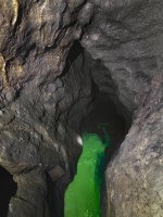
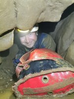
In a rare but welcome cross-club project, Rob Eavis (Eldon), Alastair Gott and me (TSG) went to the very bottom of Winnats Head Cave today and placed a depth-logger and some fluorescein dye in the terminal sump at 12.30 for John Gunn - and another important hydrological project begins. Fluocapteurs have been placed in Speedwell Cavern at Main Rising, Whirlpool Passage & Longcliffe Vein (which was dry on Wed) and on surface (actually being placed tomorrow) at Russet Well, Slop Moll, Peakshole Sough and Peak Cavern Rising. Also, logging fluorometers at Pit Props, Russet Well and at the Goosehill Bridge weir. The dye is not expected to be visible at the resurgences owing to the quantities used, but the EA have been informed just in case.
If for any reason you might be visiting any of these sites over the next month, please do not touch any of the detectors or pull on any 'strings' going underwater (bright orange electric-fence wire), as they will disturb the depth-logger readings. Also if you're thinking of doing any private dye tracing projects, please let us know!")
Many thanks to John and his helpers, including Mark McCauley and Dave Shearsmith, for installing detectors and depth-loggers elsewhere in the system. And I guess us too. Hopefully this one will pay off in all sorts of interesting ways!
All photos by Rob Eavis.
If for any reason you might be visiting any of these sites over the next month, please do not touch any of the detectors or pull on any 'strings' going underwater (bright orange electric-fence wire), as they will disturb the depth-logger readings. Also if you're thinking of doing any private dye tracing projects, please let us know!
Many thanks to John and his helpers, including Mark McCauley and Dave Shearsmith, for installing detectors and depth-loggers elsewhere in the system. And I guess us too. Hopefully this one will pay off in all sorts of interesting ways!
All photos by Rob Eavis.
Attachments
alastairgott
Well-known member
A_Northerner
Active member
Cracking work, can't wait to see the results.
Am I right in thinking that, based on the photo of the sump, its level is back down to normal again? Does the same apply to East Canal (and by extension Sump 6 of P8)? The "pulse" must have made its way through the system then...
Am I right in thinking that, based on the photo of the sump, its level is back down to normal again? Does the same apply to East Canal (and by extension Sump 6 of P8)? The "pulse" must have made its way through the system then...
pwhole
Well-known member
On my previous visit, in much wetter conditions, we could see the water surface from the pitch-head itself, so that would have been several metres higher than on Saturday - I'm guessing that what we had this time was 'normal' levels, at least if the John Beck survey elevation is anything to go by.
Attachments
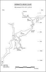
The JB survey elevation as you describe it was not his work, but a copy of my survey, but that is another matter.
The level shown on the image is how I remember it and also in line with my original survey - it was approx 8 metres from the bolts in "normal" conditions.
I also remember it being level with the stance we rigged from on a couple of occasions, but at the time never thought to link it to levels elsewhere.
I really appreciate the initiative to address the tracing and whilst the result may be predictable it will still fill a gap.
Well done guys.
pwhole
Well-known member
Ah, sorry, my mistake. I've got the paper version that stops at Fox Chamber, which states that was drawn by John, so I assumed he'd compiled the full one too.
In terms of predictability, the main significant change since last time this work was done is that Longcliffe Mine wasn't open, and we've found enough significant natural along the vein line in there to surmise that this vein-cavity development may carry on further east - and at depth, below Cowlow Nick and the Speedwell Vent. The Halfway House series is cavernous enough, and it's likely there was more of that between it and WHC before Winnats Pass was cut down. The dye trace we did a couple of years ago from Longcliffe was incredibly fast, in terms of reaching the resurgences - about a third of the time it takes from the Bottomless Pit, though admittedly that probably doesn't join the main streamway water either. My hope is that we get two main pulses of dye - one relatively fast, via our hypothetical 'new' streamway, and then a slower, longer pulse from the main Speedwell streamway. Though I'm also secretly hoping that it doesn't come out at Whirlpool Rising at all.
The swallow in Son of Longcliffe, halfway between Cowlow Nick and Longcliffe Mine was tested and again, was very fast to the resurgences. We also tested the surface-sink on Cowlow Nick itself in wet weather, near the outcrop of Longcliffe Vein, and that only came out of Peakshole Sough, but via the pressured rising in the floor near the entrance - and started arriving in nine hours. Again, strongly suggestive of a vadose streamway.
The empty space north of the main Peak-Speedwell system before the shale boundary (in plan) is large enough to hold another system of equivalent size, albeit with some volume lost due to the hill slope. The top of Longcliffe shaft is more or less level with the White River Series, so that could be another of the large avens seen in there, initiated this time as a swallet on the vein where the bedding plane topped it out as the shale cover retreated. There's a few holes I've found that fit the bill for that theory, but it would make a hell of a mess digging them out.
pwhole
Well-known member
A straight-line projection of the (cavernous) workings of Longcliffe Mine cuts through the canal, then through the (cavernous) Halfway House series, then across Winnats Pass twice and then into Winnats Head, roughly on the bearing of the final pitches/rift. I know straight lines aren't much use, but the sump in Winnats Head is roughly level with the cattle-grid outside Speedwell Cavern, so it could easily reach the main Speedwell bedding depth with a kilometre of lateral distance, if it exists that far north - though much of it is reef, so even less predictable!
The grey layer is the Therion export of all the passages known in Longcliffe and the Halfway House, so the empty space that used to hold the main survey legend is no longer empty
The grey layer is the Therion export of all the passages known in Longcliffe and the Halfway House, so the empty space that used to hold the main survey legend is no longer empty
Attachments
A_Northerner
Active member
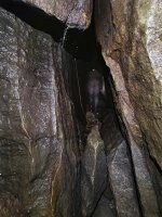
Rob said:Here's a short video showing the sump height reference the bottom pitch. Anyone any ideas?
That sump level is about 2-3m higher than I've ever seen it - in probably 5 or so trips to the bottom over the past 9 years. This could just be coincidence though.
It's certainly a few metres higher than the level was on the dive trip I previously mentioned (dated 21-3-18, so not in late summer drought conditions), because I distinctly remember placing a spit in the right hand wall whilst stood at the same height as the sump in that video, so that RobM could use an electron ladder to actually get down to the sump.
As I understand it though, based on what I heard last summer when all these recent "blockages" first came to people's attention, the level has dropped significantly. SUSS visited in mid-to-late August and drew me this quick sketch on the survey to show what they believe the level was when they visited (indicated by survey marker PW59). This would mean that in the video you linked, Alastair would probably be totally underwater!

Currently in the middle of physio rehab but once my knee has recovered I'd be interested to go and have a look at P8 Sump 6 to see if that has dropped as well.
Rob
Well-known member
Thanks for your comments.
Just checking. Presumably this is 2-3m higher than the highest you've seen it? If so, what's the lowest you've ever seen it, compared to the level in the video?A_Northerner said:That sump level is about 2-3m higher than I've ever seen it - in probably 5 or so trips to the bottom over the past 9 years...
A_Northerner
Active member
Rob said:Just checking. Presumably this is 2-3m higher than the highest you've seen it? If so, what's the lowest you've ever seen it, compared to the level in the video?
From the looks of your video it would be possible to clamber down to the water level, however from my memory I've only ever known the sump be low down in the pot, as in when you're perched on the chocked boulder in the rift (roughly where the level is in your video) there's a sheer drop of about 2-3m into the sump with little chance of clambering out, hence the need for a ladder when RobM accessed it. Because of this I've not really got much of an idea of how much it varies, because it's harder to gauge when you're just peering down at it, and at the time I wasn't thinking about the level either.
Basically, every time I've visited it's never looked like the video, it's always been a sheer pot down into it. This is obviously based on a few snapshot visits over a few years, but I've been down in plenty of different conditions (both totally dry pitches down to the sump, and abseiling in waterfalls down there).
On the right hand side of the wall above the sump there should be a spit bolt which could be a good reference point.
pwhole
Well-known member
This is extracted from a trip report I wrote from 5th Jan 2019, on a wet trip:
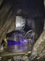
Even so, we all made it down to the bottom, despite occasional discussion of mutiny on the way - we were all very wet by now, and it is very cold down there. However, we all looked into the bottom sump eventually, all crammed onto the boulders to try and keep out of the spray (plastic suit next time!), though none of us climbed down into it, having read the guide-book.
I'm sure we were all looking down from the pitch-head, rather than where we were stood on Saturday to put the dye in, so the water level then would have been metres higher. Alastair was there, so hopefully he can remember better!
pwhole
Well-known member
Saturday was our AGM, and we had lots of folks about doing different things. As Alastair and Wayne were exiting Peak Cavern at twilight they noticed the resurgences were all looking a funny colour. We'd just got back from Bagshawe, and as it had been raining all the night before, and throughout the day, we knew what was coming, so after a few hasty phone calls we dashed back up there with empty (and rinsed!) Coca-Cola, Oasis and flavoured mineral water bottles and got samples from all the resurgences in Russet Well, Slop Moll and Peakshole Sough, and then one of the mix downstream. Even in a headlight the water coming out was visibly tinged green. By the next morning the whole system was in flood, dark brown, and more importantly no longer contained any dye. So for once the weather has worked in our favour!
It's not over yet, and the numbers will take some crunching, but it's going to be an interesting dataset when everything's retrieved
It's not over yet, and the numbers will take some crunching, but it's going to be an interesting dataset when everything's retrieved
