

You are using an out of date browser. It may not display this or other websites correctly.
You should upgrade or use an alternative browser.
You should upgrade or use an alternative browser.
Video of recent flooding?
- Thread starter Pegasus
- Start date
The Old Ruminator
Well-known member
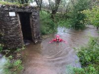
A fair few images on Facebook and seen other stills on email. Mr O'Doc took stuff in Swildons on Sunday. Mrs O'Doc clearly not amused. I expect his dinner was in the dogs. Withyhill entrance pipe gushing a stream and all of that corner of the quarry flooded. Will take a look today. Also, it looked like Gough's entrance was in flood. What folk are willing to share here is another matter. Sensibly I was at home.
The Old Ruminator
Well-known member
Almost on topic.
https://www.youtube.com/watch?v=QwsQ7JarjCE&feature=share
https://www.youtube.com/watch?v=QwsQ7JarjCE&feature=share
PaulW said:we have footage, but its not yet been edited
Looking forward to seeing it


mrodoc
Well-known member
Hello, Pegasus. I got some stick for visiting the cave on Sunday although plenty of people afterwards declared they had been down in worse conditions or during rescues. I doubt it. We emerged through the hollow tree which I think provides an escape route at all times. Also the blockhouse can be boarded up temporarily providing an escape route. However I would add that going below the Water Chamber in Swildons (where we were) is very risky in these conditions. As you will see from a forum posting one couple lost wellies and a kit bag. The film of them coming up the Water Rift is impressive. One of them had to free climb the Forty not a safe or easy option for most cavers. I filmed us going in and how much the water had risen in 2 hours when we came out as well as some of the 'pinch points'.
mrodoc said:The film will go on Youtube so visible to all.
Is there a link? I've looked and can't find anything, thank you
")
3 days later the water is still trying to escape from wookey:
https://flood-warning-information.service.gov.uk/station/3059
& Gough's:
https://flood-warning-information.service.gov.uk/station/3410
Whilst flow from Burrington has dropped off massively (although this is more affected by surface runoff):
https://flood-warning-information.service.gov.uk/station/3060
The Mells river has a lot of feeders on East Mendip:
https://flood-warning-information.service.gov.uk/station/3024?direction=u
Weather site in Bath shows almost 100mm of rain, which was mostly in first 4 days of Oct (so Thursday to Sunday). Unfortunately there don't appear to be any publicly available that are closer to Mendip & I don't know if this is PaulW, or someone else:
https://www.paulwilman.com/
The Old Ruminator
Well-known member
On Tuesday the lake in Fairy Cave Quarry had mostly drained leaving a flood gully from Withyhill to Hillwithy. The sump in Hillwithy was frothy but the only active stream could be heard below boulders not far in from the entrance.
north doodle
New member
I live on Mendip about 4 miles from the Hunters and have a Davis weather station. Here are my rain results.
30-9-20 27.8 mm
1-10-20 4.2
2-10 58.6
3-10 37.4
4-10 55.8
5-10 4.2
6-10 27.8
Total 215.8 mm ( 8.5 inches ) No rain today so far !!
30-9-20 27.8 mm
1-10-20 4.2
2-10 58.6
3-10 37.4
4-10 55.8
5-10 4.2
6-10 27.8
Total 215.8 mm ( 8.5 inches ) No rain today so far !!
Similar threads
- Replies
- 8
- Views
- 645