Cave Panoramas and Virtual Tours

footleg

Member
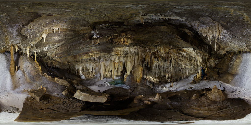
Finally fixed up my caving panoramas online to work on mobile devices. This is a new one added to the tour, taken in July 2014 a couple of days after we discovered this chamber for the first time.

21607022328_0afa8ebf50_b.jpg


The interactive tour version can be found here:
http://wscc.darkgem.com/footleg/pano/Risco.html

Flickr album https://www.flickr.com/photos/footleg/21607022328/in/album-72157625835738597/
 
indeed, very well made and a good help in documenting / preserving a cave.

A similar thing was done for a newly discoverd cave in Belgium a  few years ago. In the following virtual tour you can "walk" through the cave starting from the outside in a quarry in Sprimont (Belgium)

http://rcae-speleo.be/noubleu/virtualtour.swf

This virtual tour is used to show to the public and as documentation in the negociations between the owner of the quarry and the public services and the cavers

BR

Dagobret
 
How do you get the '360' bit to work? I can make 360 degree panorama's on my Samsung phone but cant seem to make them available on a browser - they only work on the phone.
 
Leclused said:
indeed, very well made and a good help in documenting / preserving a cave.

A similar thing was done for a newly discoverd cave in Belgium a  few years ago. In the following virtual tour you can "walk" through the cave starting from the outside in a quarry in Sprimont (Belgium)

http://rcae-speleo.be/noubleu/virtualtour.swf

This virtual tour is used to show to the public and as documentation in the negociations between the owner of the quarry and the public services and the cavers

BR

Dagobret

Very good, in fact excellent!  I like caving without getting my feet wet  :lol:
 
Walrus said:
How do you get the '360' bit to work? I can make 360 degree panorama's on my Samsung phone but cant seem to make them available on a browser - they only work on the phone.

You need to start with a photograph which covers the entire 360/180 space (like the bitmap shown in my post, which is an equatorial projection - like a flattened map of the world). From this you can generate web compatible pages using a number of viewers (all commercial as far as I am aware). I am using krpanotools and their krpano viewer. Very powerful but a bit techie to customise (done by writing XML configuration files). There is a graphical tour builder tool from Kolor software (which uses krpano under the hood, but you don't need to know that to use it). The other commonly seen alternative is from Garden Gnome software. Google any of those, or just panorama viewer to find out more.
 
footleg said:
Nice tour Dagobret. A nice example of the things that krpano viewer is capable of which I am not using in my tour. Built using the Kolor UI builder as far as I can see?

I included additional photos and a map in a different way in the Los Hoyos tour (linked from my other panos, but here is a direct link: http://wscc.darkgem.com/footleg/pano/LosHoyosTour.html )

The maker, Vincent Gerber, published the how-to in a document. You can find it here

http://en.calameo.com/read/002039698a830aa749f18?authid=Yv3scoYzzX7A&view=book

BR

Dagobert
 
Back
Top