• Black Sheep Diggers presentation - March 29th 7pm

    In the Crown Hotel Middlesmoor the Black Sheep Diggers are going to provide an evening presentation to locals and other cavers.

    We will be highlighting with slides and explanations the explorations we have been doing over the years and that of cave divers plus research of the fascinating world of nearby lead mines.

    Click here for more details

History of Matlock mines, caves - book progress update

Thought it appropriate to explain the progress of the Matlock book – slow, although it has had all my spare time for years.

Last summer, I signed off the text to the editor, whose verdict was that it was “a phenomenal piece of work”. The reaction of the PDMHS chairman was to introduce me to people at Matlock, telling them that I know “a hundred times more” about the mines than anyone else (no pressure there then!). I must admit that it was a relief to hear my pre-eminence in this field at last publicly acknowledged, even if it was exaggerated.

I have recently sent the editor the 61 diagrams, many of them complex. Much time had been wasted drawing these by hand and scanning them, which resulted in a very unsatisfactory appearance. In the nick of time, I managed to acquire enough facility with Photoshop to substantially rework the diagrams – thought it worthwhile because otherwise they would have spoiled the book.

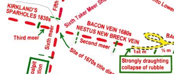
I guess many enthusiasts will first turn to the detailed area maps, which instantly render obsolete those already published and would have been worth a fortune to the fluorspar miners. For instance, when Lewis Pearson drove the incline level towards what was (wrongly) called Black Ox Title in 1970, he was in fact acting on a vague rumour that there was a lost pipe on the east side of Masson Cavern. He had only a few thousand pounds of financial backing and I chatted with him in the level just before its abandonment but he had wrongly located the drive. I now know the name of the lost pipe, its position and history – its filled-in shafts were still visible if one knew where to look. This is just one of the lost systems associated with Masson, which lie like time capsules waiting to be unearthed if any serious underground blokes should ever turn up – needs someone like the late Doug Nash or Lawrence Hurt.

Amusingly, someone wrote in a recent PDMHS publication that the incline level was intended to pass through the Lower Lava so as to work the Black Ox Title beneath. In fact, the lava there is about 250 feet thick, the incline would have to have been some 1,500 feet long, but no proven deposits exist beneath. Not even the largest mineral company would undertake such a gamble. It is so easy to write to that standard but so very difficult to get to the truth.

For the diagrams, I began by reassessing the original archive sources, which yielded some new interpretations, for instance the exact location of Bennett Hole, an obscure cave in High Tor far away from the prominent openings on Hard Rake and High Tor Rake. Twenty years ago, I had deduced the correct range of Bennett Hole Vein and assumed that the “hole” (cave) was near river level but a field trip drew a blank. The new source showed it was half way up the cliff face and I again visited the site but could find no reasonable way of approach from any direction, annoying because this may have been the long-lost hermit’s cave and therefore historically important. Presumably, Bennett Hole was a small cave-pipe vein/mine developed within the strata of reef knoll limestone in High Tor, similar to Cockaberry Hole in the bed of cockleshells in Lovers Walks at Matlock Bath, which I have discussed elsewhere. If so, it should be mentioned (tho’ not by name) in D. Biggins 1970 PhD thesis about the Carboniferous reef knoll at High Tor but I have not had sight of this. Could find nothing about it in caving literature (being on a caving website, I had better confess that I have never had anything to do with caves, only recording them as a historian). If anyone, caver or climber, has come across this cave, perhaps they could post details here – I cannot make additions to the book now.

Apologies for both the delays and the length of this post, which is intended to illustrate the difficulties faced in compiling a definitive account (as opposed to the usual skim-over standard) in the hope that interested parties might continue to show patience. To those that do, my sincere thanks for, without people taking an interest, such daunting projects would be merely empty academic exercises.
 
Apologies for both the delays and the length of this post, which is intended to illustrate the difficulties faced in compiling a definitive account (as opposed to the usual skim-over standard) in the hope that interested parties might continue to show patience. To those that do, my sincere thanks for, without people taking an interest, such daunting projects would be merely empty academic
I’m sure I’m not the only one here who cut their teeth in Matlock Bath having read your earlier book(s) on Masson. The new Magnum Opus is indeed eagerly awaited, and I’m sure will give us the nudge to (discretely of course, and with the necessary permissions) put spades to ground again.
 
Thank you all for the kind words of encouragement. With always working alone, enthusiasm wanes at times.

I notice that Boy Engineer might be tempted to start digging. Besides potential use for locating the thermal water outflow from a sough at Willersley, I wondered if a thermal imaging camera might be sensitive enough to detect the temperature difference in air issuing from a surface blockage

One of the great prizes at Matlock Bath would be to regain entry to the extensive Bacon Pipe (with its 300 foot plus range of long-lost natural caverns) – Gilderoy – Smedley’s Venture – Tower Vein – Wragg Mine system. People who have written about the Devonshire area have not known about this, not being familiar enough with the area. During the early 1960s, some very casual underground explorers found an easy way into the lower part of this system but, infuriatingly, it has defied my attempts to locate it. There were several shaft entrances and several adit entrances, so it is probable that some survive, albeit sealed over. It looks as though there was an adit entrance in the retaining wall alongside Holme Road and about ten years ago, on a hot day, I examined the length of the wall above the road carefully, holding my face close to any promisingly loose looking stones in the hope of detecting a cool draught but to no avail. It needs a more scientific approach. LiDAR scans are u/s in that area because of the tree cover, buildings, and developments.

Twenty years ago, underground explorers on Spar Holes Vein came up to the blockage just short of Bacon Pipe and noted it was a strongly draughting collapse but they did not even try to dig it!! What does it take these days to get blokes digging? What does there need to be on the other side of the collapse? An entire troupe of sex-starved dancing girls? Would that do the trick? Perhaps the unguarded rear entrance to Fort Knox? Or would it take (and this would be the ultimate) a fish n’ chip shop doing free takeaways? Oh, well, attitudes change and exploration just is not fashionable any more.
 
Good work Roger - rest assured if I were closer to Matlock I would probably be working on projects more often, but Castleton is the only practical area for me sadly. Can't wait for the publication though, and may still be able to help with any last-minute image issues if they come up.
 
Thank you all for the kind words of encouragement. With always working alone, enthusiasm wanes at times.

I notice that Boy Engineer might be tempted to start digging. Besides potential use for locating the thermal water outflow from a sough at Willersley, I wondered if a thermal imaging camera might be sensitive enough to detect the temperature difference in air issuing from a surface blockage

One of the great prizes at Matlock Bath would be to regain entry to the extensive Bacon Pipe (with its 300 foot plus range of long-lost natural caverns) – Gilderoy – Smedley’s Venture – Tower Vein – Wragg Mine system. People who have written about the Devonshire area have not known about this, not being familiar enough with the area. During the early 1960s, some very casual underground explorers found an easy way into the lower part of this system but, infuriatingly, it has defied my attempts to locate it. There were several shaft entrances and several adit entrances, so it is probable that some survive, albeit sealed over. It looks as though there was an adit entrance in the retaining wall alongside Holme Road and about ten years ago, on a hot day, I examined the length of the wall above the road carefully, holding my face close to any promisingly loose looking stones in the hope of detecting a cool draught but to no avail. It needs a more scientific approach. LiDAR scans are u/s in that area because of the tree cover, buildings, and developments.

Twenty years ago, underground explorers on Spar Holes Vein came up to the blockage just short of Bacon Pipe and noted it was a strongly draughting collapse but they did not even try to dig it!! What does it take these days to get blokes digging? What does there need to be on the other side of the collapse? An entire troupe of sex-starved dancing girls? Would that do the trick? Perhaps the unguarded rear entrance to Fort Knox? Or would it take (and this would be the ultimate) a fish n’ chip shop doing free takeaways? Oh, well, attitudes change and exploration just is not fashionable any more.
I have access to a reasonable thermal camera. They generally can't see thermal gradients in the air, water acts as a barrier to thermal cameras, and can in fact reflect IR heat from other objects. They might pick up on things that are warmed up by the warm air, walls, tree etc... or cooled down in summer, for instance... depends on the differential, and material to be measured. So for instance, ground above a shake or similar might give something away... if there is a good draught... Best time would be either very warm weather or very cold weather, but not when the ambient temperature is similar to that of the case (i.e. within a few degrees I'd think).
 
Twenty years ago, underground explorers on Spar Holes Vein came up to the blockage just short of Bacon Pipe and noted it was a strongly draughting collapse but they did not even try to dig it!! What does it take these days to get blokes digging? What does there need to be on the other side of the collapse? An entire troupe of sex-starved dancing girls? Would that do the trick? Perhaps the unguarded rear entrance to Fort Knox? Or would it take (and this would be the ultimate) a fish n’ chip shop doing free takeaways? Oh, well, attitudes change and exploration just is not fashionable any more.
I guess part of the problem is that very few people currently know where Spar Holes is, or how much is there - the Troggs found it of course! Terry Worthington said to me that he reckoned there's likely a system of similar size to Devonshire there and from what I've seen of the currently accessible bits, I'd agree. However, being inside the SSSI means that you'd need to get Natural England's permission for digging.
It does seem to be the case these days that pretty much all the digging going on is up at the top end of the orefield.
 
Looking forward to learning of this Spar Holes and maybe getting a grovel. My knowledge of it at present is very lacking! Perhaps someone in the know would PM me some information?
 
The quick answer is to the north of Coalpithole Rake - have a look at the section in https://pdmhs.co.uk/MiningHistory/Bulletin 17-3 - Metal Mines through Time.pdf covering Devonshire, there's a map showing the area. One note of caution for that area, the shafts around there are capped with light weldmesh that gets covered in leaves making them hard to see, both John Barnatt and I have had brown-trouser moments when we trod on one of these and felt the mesh start to give!
 
Boy Engineer confirms what Tangent Tracker states re thermal imaging. Thought I was being optimistic. Another way is to look for areas of melting snow in winter but that is a rarity nowadays.
AR is correct that the Sparholes dig requires permission - also from the owners of the Heights of Abraham for access.
Should not really be doing this, but attached is a snippet from my plan of Rutland - Nestus from the forthcoming book, showing the connection point. Bacon Pipe is the vein going from top to bottom. The left - right vein is Spar Hole alias Bacon Vein alias Nestus New Breck. These details also appear on the survey published in our 1976 book about Matlock Bath but not as clearly. A detailed and accurate survey by John Barnett appeared in the PDMHS bull. report on the exploration of Lower Nestus but not showing these peripheral details: it does show the collapse.
It would be a lot easier to find one of the lower entrances - I suspect that the 1960s explorers got in through a level in someone's back garden. They emerged, looking rather bewildered, from another level on the boundary between two other back gardens - this latter level has now completely collapsed and the landowners (one a friend of mine, and a very reasonable person) will not permit it to be dug open. However, there is no certainty that getting in at the Coalpit Rake end would allow one to get right up to the Bacon Pipe caverns. Bacon Pipe downhill becomes Gilderoy Vein, crossing Coalpit Rake at right angles.. It must be a very similar vein to the downhill Gentlewoman's Pipe, as it too leads off the Masson Pipes and has extensive natural features, and eventually goes into the Gilderoy soughs.
I still use the computers in the local library for internet access, which means my time on line is limited and liable to be infrequent - sorry about that.
 

Attachments

  • connection.jpg
    connection.jpg
    84.4 KB · Views: 68
I spent quite a lot of time in the Masson Mine system during the 1980's and there were a number of interesting leads.

On the main Bacon Rake entrance to the show cave there were two small workings on the south side that you could enter. One of these had a very strong draft coming up through the rubble floor during cold weather and at the time I assumed this was coming up from Rutland.

I spend a bit of time digging here but it was starting to look a bit dodgy without putting in proper support and spoil stacking space was a problem so I moved on to other sites.

Unfortunately I think a load of waste might have been pushed into this area when upgrades to the show cave were made.
 
I think Terry Worthington and John Barnatt did get through that connection from Rutland into the entrance level of Masson Cavern.

Am now sorting out the illustrations - engravings, photos, etc for the book, clearing copyrights &c. A chance in a million this, but does anyone have a photo of the Harveydale Quarry Tubes? They are by far the most extensive cave in the Matlock Gorge at 1500 feet length but were largely ignored and no proper survey done - am lucky to have Peter Freeman's sketch survey. Now blocked off behind steel netting in the quarry. Two of the tubes led into an engine shaft on Seven Rakes at different altitudes, which suggests that shaft may have been sunk in a lumbhole (a natural pothole). Not being knowledgeable about cave formation, I wondered if the tubes might have crossed Seven Rakes (as did Gentlewoman's Pipe) and carried on uphill to the west.
I'm not aware of any photographs. From what Doug and others told me they were very tight. There is Doug Nash a sketch and description in the e OP Mole records if they still exist but I don't think they crossed the rake. I think that he may also have published something elsewhere.

Unfortunately I don't know what happened to the Bound copies of OP Mole records when Doug's house was cleared. The bound copies ran from 1949 until around 1967 from what I remember.
They're in the PDMHS library, the BCA library passed the mining-related bits of the Nash-Beck collection over to us.
 
Did PDMHS by any chance get Doug's photo albums at the same time?

There was a good selection of photos from the intact Jug Holes adit, as well as the beehive slopes when they were still white plus lots of rarely visited sites.
 
Back
Top