Mandale Mine Blockage

wellyjen

Well-known member
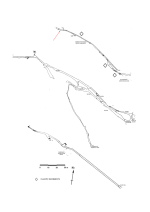
We had an evening trip to Mandale Mine yesterday. There has been a recent movement of wet clay that has slumped and blocked the way on at the point marked. Reasonably sure that this is the place that PDMHS had to dig through to reach the current known extent, fifty plus years ago. Will need to be dug out, probably in to sandbags, given its sloppy nature to restore access to the far end.
See the arrow for the location in the PDMHS elevation below.

mandale.png
 
I can't remember. Been too long since I was last there. If there was timber, it is now buried. You could see the continuation of the old floor of light coloured gravel disappearing under the clay.
Edit: It is a short distance beyond the way in to the side passage with the deep water/sump at one end and the rising climb at the other
 
Last edited:
Is this at the point where you had to crawl under some modern timber support?
I think so - I recall some kind of shoring, either wood or an oil drum. If remember correctly, it was followed by a climb back down to water level and some steps across boulders in the flooded stope. I climbed up the wet clay and there appears to be a top to the current slump, but it is very wet and will probably need sandbagging as it is dug. IF it's where I think, there is quite a lot of space in the lower stope for spoil - albeit once it is reaccessed.
When we were going there we overshot a little and there was some very impressive flood damage to the main path through Lathkill Dale, with some of it washed away to a depth of nearly 2 foot. There must have been a massive amount of water running through, and we wondered if that had contributed to the slumping
 
The slump is at the far end of the chamber with the massive boulder in the roof (I remembered it from previous trips, hopefully makes sense)
 
I can't remember the boulder in the roof, sadly - its years since I was there. This is the flooded stope, looking back toward the entrance in this shot. So it's further into the mine than here? But before the big chamber with the shaft in the roof that the sough pours into? That's shown below it - the timber shoring I mean is further up the sough, just before the pronounced left-right hop from Pasture Rake to Mandale Rake.

_IGP3113_sm.jpg


_IGP3097_sm.jpg
 
On the PDMHS survey used in the SSSI monitoring document, it is at the far end of the then explored mine. A short distance beyond the deep pool on the south side of the main passage that is marked as a sump on the survey.
mandale.png


mandale.png
 

Attachments

  • mandale.png
    mandale.png
    98.6 KB · Views: 36
Back
Top